Approximate Location Map
Large Map »
Latitude: 51.501 / 51°30'3"N
Longitude: -0.1531 / 0°9'11"W
OS Eastings: 528293
OS Northings: 179622
OS Grid: TQ282796
Mapcode National: GBR 9J.T3
Mapcode Global: VHGQZ.9JFP
Plus Code: 9C3XGR2W+9Q
Entry Name: 16 and 17, Grosvenor Crescent SW1
Listing Date: 1 December 1987
Grade: II
Source: Historic England
Source ID: 1214157
English Heritage Legacy ID: 209951
ID on this website: 101214157
Location: Hyde Park Corner, Westminster, London, SW1X
County: London
District: City of Westminster
Electoral Ward/Division: Knightsbridge and Belgravia
Parish: Non Civil Parish
Built-Up Area: City of Westminster
Traditional County: Middlesex
Lieutenancy Area (Ceremonial County): Greater London
Church of England Parish: St Paul Knightsbridge
Church of England Diocese: London
Tagged with: Embassy
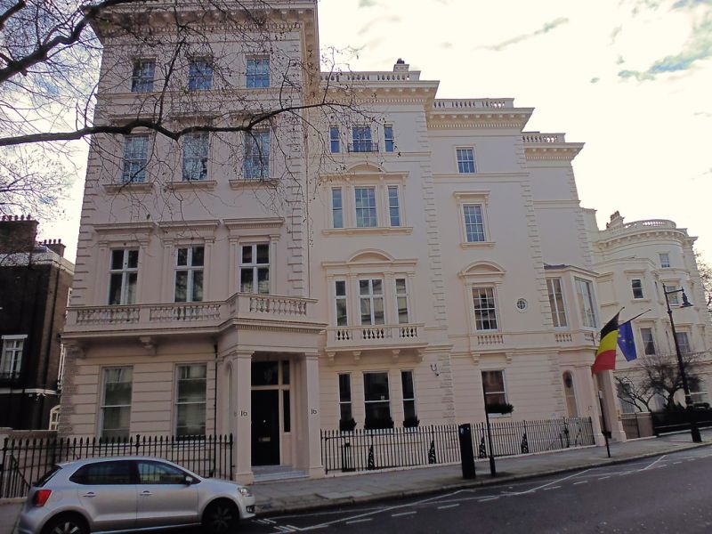
TQ 2879 NW CITY OF WESTMINSTER GROSVENOR CRESCENT, SW1
88/28 (south side)
Nos 16 and 17
GV II
Pair of houses. Mid C19. Stucco. Lead mansard roof. No 16 is 3 windows wide.
No 17 has 3 bays, stepped back. Projecting porches. Channelling to ground
floor. Square headed windows. Sashes and casements. Some small panes.
Rusticated quoins. Included for group value,with Nos 1 to 10 (consec) Grosvenor
Crescent (qv), only.
Listing NGR: TQ2829379622
External links are from the relevant listing authority and, where applicable, Wikidata. Wikidata IDs may be related buildings as well as this specific building. If you want to add or update a link, you will need to do so by editing the Wikidata entry.


Other nearby listed buildings
