Latitude: 53.1443 / 53°8'39"N
Longitude: -1.1954 / 1°11'43"W
OS Eastings: 453911
OS Northings: 361092
OS Grid: SK539610
Mapcode National: GBR 8F5.YBX
Mapcode Global: WHDFZ.L7YC
Plus Code: 9C5W4RV3+PR
Entry Name: 5 and 7, Church Street
Listing Date: 21 March 1994
Grade: II
Source: Historic England
Source ID: 1214269
English Heritage Legacy ID: 391688
ID on this website: 101214269
Location: Mansfield, Nottinghamshire, NG18
County: Nottinghamshire
District: Mansfield
Electoral Ward/Division: Portland
Parish: Non Civil Parish
Built-Up Area: Mansfield
Traditional County: Nottinghamshire
Lieutenancy Area (Ceremonial County): Nottinghamshire
Church of England Parish: Mansfield St Peter and St Paul
Church of England Diocese: Southwell and Nottingham
Tagged with: Building
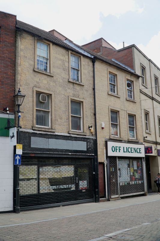
MANSFIELD
SK5361 CHURCH STREET
924-1/5/33 (North East side)
Nos.5 AND 7
GV II
2 houses, now 2 shops. Early C19, with late C20 alterations.
Coursed squared stone with stone dressings and concrete tile
roofs. No.7, to right, slightly higher. 3 storeys; 4-window
range of plain sashes. Above, to left, two 12-pane sashes. To
right, 2 similar sashes, the right one partly reglazed. Ground
floor has a central entry doorway flanked by late C20 shop
fronts.
Listing NGR: SK5391161092
External links are from the relevant listing authority and, where applicable, Wikidata. Wikidata IDs may be related buildings as well as this specific building. If you want to add or update a link, you will need to do so by editing the Wikidata entry.


Other nearby listed buildings