Approximate Location Map
Large Map »
Latitude: 50.6834 / 50°41'0"N
Longitude: -3.2359 / 3°14'9"W
OS Eastings: 312781
OS Northings: 87809
OS Grid: SY127878
Mapcode National: GBR P8.XMR2
Mapcode Global: FRA 4738.H59
Plus Code: 9C2RMQM7+9J
Entry Name: Bridge
Listing Date: 12 October 1951
Grade: II
Source: Historic England
Source ID: 1216266
English Heritage Legacy ID: 401620
ID on this website: 101216266
Location: New Town, East Devon, EX10
County: Devon
District: East Devon
Civil Parish: Sidmouth
Built-Up Area: Sidmouth
Traditional County: Devon
Lieutenancy Area (Ceremonial County): Devon
Church of England Parish: Salcombe Regis St Mary and St Peter
Church of England Diocese: Exeter
Tagged with: Road bridge
SALCOMBE ROAD
1.
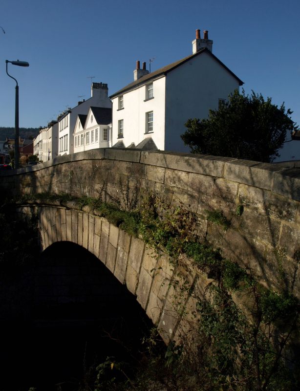
1633
(North Side)
Bridge
SY 1287 1/115 12.10.51.
II GV
2.
1817. Slightly humped. One segmental arch with rusticated voussoirs
and quoins. String course below parapet with granite coping terminating
in circular piers.
The Bridge and Toll House form a good group.
Listing NGR: SY1278187809
External links are from the relevant listing authority and, where applicable, Wikidata. Wikidata IDs may be related buildings as well as this specific building. If you want to add or update a link, you will need to do so by editing the Wikidata entry.


Other nearby listed buildings
