Approximate Location Map
Large Map »
Latitude: 51.3582 / 51°21'29"N
Longitude: 0.195 / 0°11'42"E
OS Eastings: 552928
OS Northings: 164411
OS Grid: TQ529644
Mapcode National: GBR T0.CTC
Mapcode Global: VHHPD.B4G4
Plus Code: 9F32955W+72
Entry Name: The Gatehouse to Lullingstone Castle
Listing Date: 1 June 1967
Grade: I
Source: Historic England
Source ID: 1217173
English Heritage Legacy ID: 411975
ID on this website: 101217173
Location: Lullingstone, Sevenoaks, Kent, DA4
County: Kent
District: Sevenoaks
Civil Parish: Eynsford
Traditional County: Kent
Lieutenancy Area (Ceremonial County): Kent
Church of England Parish: Lullingstone St Botolph
Church of England Diocese: Rochester
1. EYNSFORD LULLINGSTONE LANE
5280 Lullingstone
The Gatehouse to
TQ 56 SW 5/64 1.6.67 Lullingstone Castle
I
GV
2.
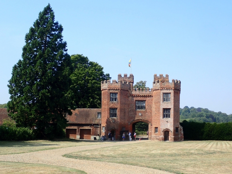
C16. This was the outer Gatehouse of the house built by Sir Percyvall Hart between
1543 and 1580. (Of which parts remain in the later Lullingstone Castle) and
was constructed sometime after the middle of the century. The inner Gatehouse
was demolished in the mid C18. Red brick laid in English Bond, with traces of
diaper pattern. In plan it consists of a rectangle with polygonal turrets attached
to the outer face, and polygonal projections from the inner. In elevation it
comprises a carriage archway with a room over flanked by turrets of 3 storeys.
Machicolation and a castellated parapet to the whole. Casement windows with
brick mullions. The outer side faces west and has a 4-centred brick carriage
archway which retains its original ribbed double doors of 20 panels, and over
it a cartouche and a single window of 2 tiers of 4 lights. Flanking this are
hexagonal staircase turrets which rise higher than the remainder of the Gatehouse.
These have quatrefoil loop lights and terracotta panels. Otherwise this side
of the Gatehouse is blind.
On the inner side is a similar moulded archway with brick dripstone and cartouche
and similar window over and these are flanked by canted bays of 3 storeys which
contain 4-centre pedestrian doorways with dripstones on the ground floor flanked
by small rectangular single light windows and windows of 2 tiers of 3-lights
on the first and second floors. AM.
Listing NGR: TQ5301664385
External links are from the relevant listing authority and, where applicable, Wikidata. Wikidata IDs may be related buildings as well as this specific building. If you want to add or update a link, you will need to do so by editing the Wikidata entry.


Other nearby listed buildings
