Approximate Location Map
Large Map »
Latitude: 51.1824 / 51°10'56"N
Longitude: 0.9374 / 0°56'14"E
OS Eastings: 605389
OS Northings: 146677
OS Grid: TR053466
Mapcode National: GBR SXQ.XF1
Mapcode Global: VHKKH.6JFX
Plus Code: 9F325WJP+XX
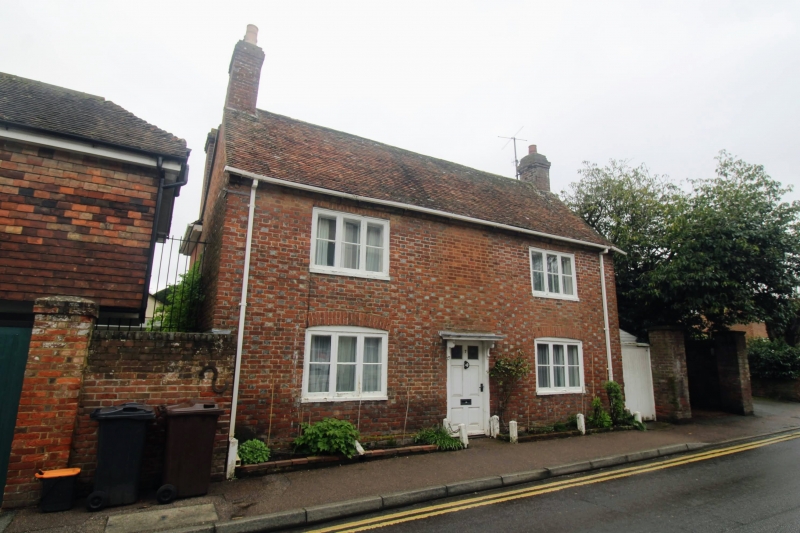
Entry Name: 7, Upper Bridge Street
Listing Date: 16 February 1989
Grade: II
Source: Historic England
Source ID: 1217548
English Heritage Legacy ID: 412662
ID on this website: 101217548
Location: Wye, Ashford, Kent, TN25
County: Kent
District: Ashford
Civil Parish: Wye with Hinxhill
Built-Up Area: Wye
Traditional County: Kent
Lieutenancy Area (Ceremonial County): Kent
Tagged with: Building
TR 0446 0546 WYE UPPER BRIDGE STREET
(north side)
8/297 No. 7
GV II
House. Mid C18. Red and blue brick with plain tiled roof. Two parallel
ranges. Two storeys with stacks to left and to right. Two 3 light wooden
casements on 1st floor and 2 on ground floor with segmental heads. Central
door of 6 raised and fielded panels, the top 2 glazed, with flat hood on
brackets. Boarded gate to right with gate pier attached.
Listing NGR: TR0539046679
External links are from the relevant listing authority and, where applicable, Wikidata. Wikidata IDs may be related buildings as well as this specific building. If you want to add or update a link, you will need to do so by editing the Wikidata entry.


Other nearby listed buildings
