Approximate Location Map
Large Map »
Latitude: 54.9065 / 54°54'23"N
Longitude: -1.3802 / 1°22'48"W
OS Eastings: 439841
OS Northings: 557035
OS Grid: NZ398570
Mapcode National: GBR VCY.W0
Mapcode Global: WHD55.RYZ0
Plus Code: 9C6WWJ49+HW
Entry Name: Borough Social Services Area Office
Listing Date: 17 October 1994
Grade: II
Source: Historic England
Source ID: 1217980
English Heritage Legacy ID: 391584
ID on this website: 101217980
Location: Sunderland, Tyne and Wear, SR1
County: Sunderland
Electoral Ward/Division: Hendon
Parish: Non Civil Parish
Built-Up Area: Sunderland
Traditional County: Durham
Lieutenancy Area (Ceremonial County): Tyne and Wear
Church of England Parish: Hendon
Church of England Diocese: Durham
Tagged with: Architectural structure
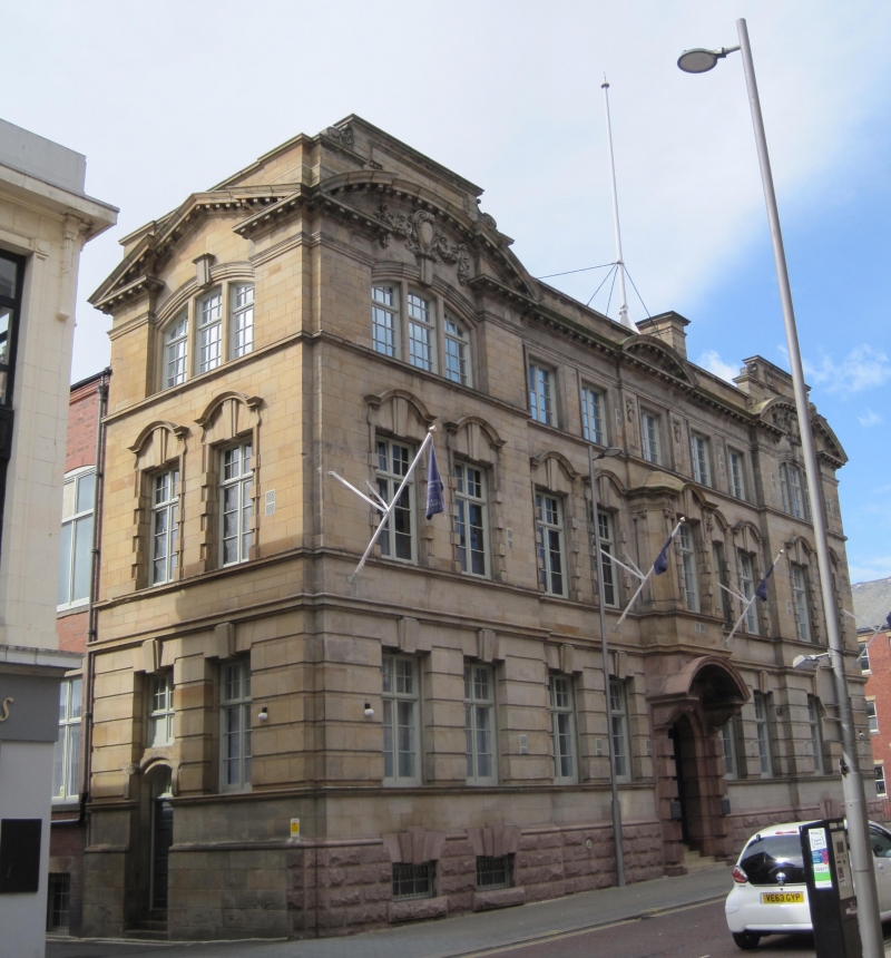
SUNDERLAND
NZ3957SE SAINT THOMAS' STREET
920-1/18/209 (South side)
No.4
Borough Social Services Area Office
GV II
Formerly known as: River Wear Commission Offices ST THOMAS'
STREET.
River Wear Commissioners' offices, now Borough Social
Services' Area office. 1907. By John Hall. Scottish red
granite, rock-faced basement and polished doorcase; Durham
sandstone ashlar. Slate roof. Free Baroque style.
EXTERIOR: 2 storeys and basement, 7 windows. Basement windows
in outer bays. Ground floor has banded rustication. Central
bay has wrought-iron gates to internal steps up to double
panelled door. Rusticated entrance surround has open segmental
pediment hood on Tuscan pilasters and big scroll brackets; big
key cartouche with carved pair of dividers. 2-storey oriel
above has top segmental pediment. Outer pairs of bays project
under open segmental pediments. Windows with vertical glazing
bars in double-keyed architraves except basement triple keys.
Roof parapet has raised bracketed panels over outer pediments.
Right return to John Street 2:2:2 bays in similar style.
INTERIOR: partly inspected. Alabaster and marble archway from
entrance to oak-panelled hall and stair-well with oak columns,
Tuscan on ground floor and Ionic above, with moulded
entablatures. Open-well stair and gallery with ramped wide
grip handrail on turned balusters; close string with
laurel-wreath pulvinated frieze. Panelled doors on both levels
have architrave surrounds with pulvinated frieze and cornice.
First-floor board room has moulded panels with raised fields,
pilasters with carved swags, carved entablature,
bolection-moulded marble fire surrounds, segmental-arched
ceiling with bands of rich stucco decoration.
A building which represents the considerable history of the
management of the Wear. The Commission was set up in 1717.
(Corfe T: The Buildings of Sunderland 1814-1914: Newcastle
upon Tyne: 1983-: 31; Corfe T: Sunderland A Short History:
Newcastle upon Tyne: 1973-: 49,50; Milburn GE and Miller ST:
Sundrland River, Town and People: Sunderland: 1988-: 158, 167
NOTE 32).
Listing NGR: NZ3984157035
External links are from the relevant listing authority and, where applicable, Wikidata. Wikidata IDs may be related buildings as well as this specific building. If you want to add or update a link, you will need to do so by editing the Wikidata entry.


Other nearby listed buildings
