Approximate Location Map
Large Map »
Latitude: 53.7402 / 53°44'24"N
Longitude: -2.9846 / 2°59'4"W
OS Eastings: 335157
OS Northings: 427537
OS Grid: SD351275
Mapcode National: GBR 7TL5.NZ
Mapcode Global: WH85P.4811
Plus Code: 9C5VP2R8+35
Entry Name: Estate Boundary Wall to South and West of Lytham Hall, with Gateway at Hey Houses
Listing Date: 13 January 1971
Last Amended: 15 February 1993
Grade: II
Source: Historic England
Source ID: 1218602
English Heritage Legacy ID: 385239
ID on this website: 101218602
Location: Fairhaven, Fylde, Lancashire, FY8
County: Lancashire
District: Fylde
Electoral Ward/Division: Ansdell
Parish: Non Civil Parish
Built-Up Area: Lytham St Anne's
Traditional County: Lancashire
Lieutenancy Area (Ceremonial County): Lancashire
Church of England Parish: Lytham St Cuthbert
Church of England Diocese: Blackburn
Tagged with: Wall
LYTHAM ST ANNES
SD32NE BLACKPOOL ROAD, Lytham
621-1/3/19 (North East side)
13/01/71 Estate boundary wall to S and W of
Lytham Hall, with gateway at Hey
Houses
(Formerly Listed as:
LYTHAM
Estate boundary wall to south and
west of Lytham Hall)
GV II
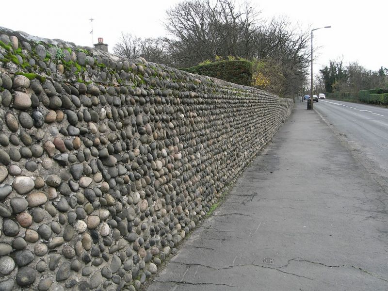
Part of boundary wall of Lytham Hall estate. Probably later
C18 or early C19; altered and recently partly demolished.
Built of cobblestones with rendered capping. Follows gently
curved line 1.2 miles long extending from west side of Church
Lodge westwards and northwards as far as Hey Houses,
interrupted by the railway line and recently further
interrupted by entrances to a modern housing estates. Approx.
2 metres high (except where altered or reduced). North end
terminates at a former gateway with a set of 4 gate piers at
Hey Houses: all square, the inner pair taller than the outer
pair, and of rusticated sandstone with pebble panels, moulded
cornices and shallow pyramidal caps; and a pair of cast-iron
gates. Typical of local craftsmanship, and adjacent to similar
work at Church Lodge.
Listing NGR: SD3515727537
External links are from the relevant listing authority and, where applicable, Wikidata. Wikidata IDs may be related buildings as well as this specific building. If you want to add or update a link, you will need to do so by editing the Wikidata entry.


Other nearby listed buildings
