Latitude: 54.5411 / 54°32'28"N
Longitude: -1.924 / 1°55'26"W
OS Eastings: 405015
OS Northings: 516210
OS Grid: NZ050162
Mapcode National: GBR HH0X.8X
Mapcode Global: WHB4L.F411
Plus Code: 9C6WG3RG+FC
Entry Name: 34, the Bank
Listing Date: 24 February 1950
Last Amended: 28 November 1994
Grade: II*
Source: Historic England
Source ID: 1218764
English Heritage Legacy ID: 388827
ID on this website: 101218764
Location: Startforth, County Durham, DL12
County: County Durham
Civil Parish: Barnard Castle
Built-Up Area: Barnard Castle
Traditional County: Durham
Lieutenancy Area (Ceremonial County): County Durham
Church of England Parish: Barnard Castle with Whorlton
Church of England Diocese: Durham
Tagged with: Building
BARNARD CASTLE
NZ0516SW THE BANK
770-1/6/198 (East side)
24/02/50 No.34
(Formerly Listed as:
THE BANK
(East side)
Nos.34, 36 AND 36A (Even))
GV II*
Inn, now house. Dated 1742. Incorporates C17 fabric in rear
wing. Ashlar with plinth and painted rusticated quoins; roof
of stone slates with stone gable copings and ashlar and
rendered chimneys.
EXTERIOR: 3 storeys; 4-window range, with 2-storey rear wing.
Steps up to wide 2-panel door in second bay in architrave with
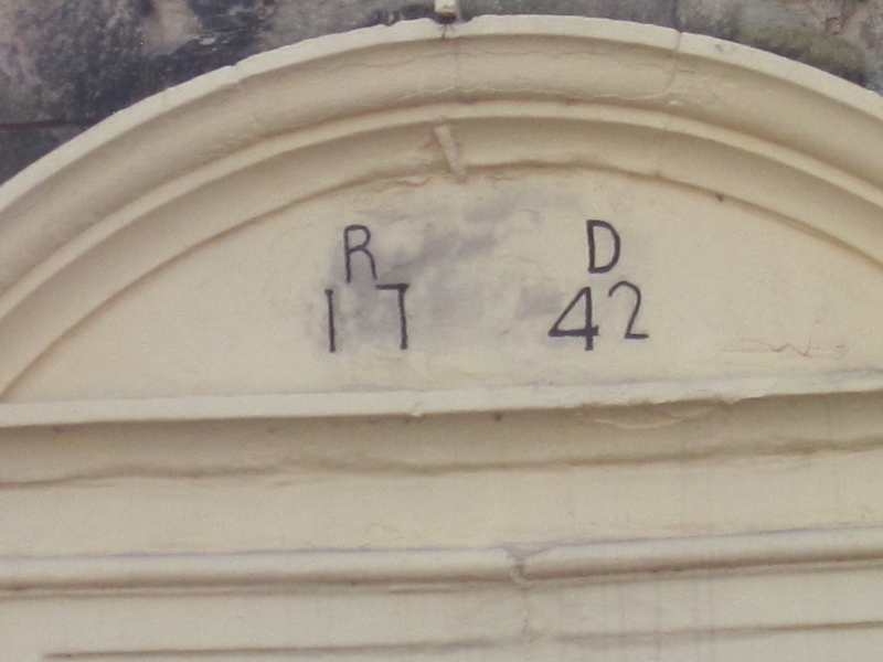
segmental pediment. Date and initials: `RD 1742' inscribed in
pediment. Cross-casement window to left of door in plain
reveals said to be inserted in former vehicle entrance.
Architraves and projecting stone sills to other similar tall
windows on ground and first floors and smaller 2-light
casements on top floor which abut top entablature with eaves
gutter cornice. Roof has slightly swept eaves, stone gable
copings on cyma-moulded kneelers, and rendered end chimneys on
stone plinths. Rear wing has stone and wood lintels over
varied openings.
INTERIOR: dogleg stair with turned balusters and newels and
closed string. Boarded and 2-panel doors on top floor; windows
in splayed reveals which drop to form seats. Roof completely
ceiled and without any access. Rear wing, partly plastered and
with first-floorboards removed, shows first-floor fire with
flat Tudor-arched stone surround, some wood-mullioned windows,
and one window on internal wall has lozenge leaded glazing
with original glass in situ although damaged.
HISTORY: built as an inn: the Hat and Feather, according to
owner's deeds. Later known as the Turk's Head, then the
Shoulder of Mutton until 1955; known locally as the Bucket of
Blood. Derelict until restored by present owner; rear wing not
yet restored.
Listing NGR: NZ0501516209
External links are from the relevant listing authority and, where applicable, Wikidata. Wikidata IDs may be related buildings as well as this specific building. If you want to add or update a link, you will need to do so by editing the Wikidata entry.


Other nearby listed buildings