Latitude: 50.6833 / 50°40'59"N
Longitude: -1.3782 / 1°22'41"W
OS Eastings: 444025
OS Northings: 87256
OS Grid: SZ440872
Mapcode National: GBR 8BM.0DH
Mapcode Global: FRA 8708.DXC
Plus Code: 9C2WMJMC+8P
Entry Name: The Temple
Listing Date: 18 January 1967
Last Amended: 30 December 1994
Grade: II
Source: Historic England
Source ID: 1218782
English Heritage Legacy ID: 393011
ID on this website: 101218782
Location: Ashengrove, Isle of Wight, PO30
County: Isle of Wight
Civil Parish: Calbourne
Traditional County: Hampshire
Lieutenancy Area (Ceremonial County): Isle of Wight
Church of England Parish: Calbourne All Saints
Church of England Diocese: Portsmouth
Tagged with: Architectural structure
CALBOURNE
SZ48NW NEWPORT ROAD 1354-0/6/122 The Temple 18/01/67 (Formerly Listed as: The Temple on the Estate of Swainston)
II
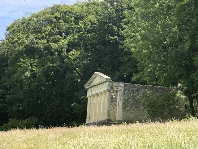
Ornamental garden building, being converted to dwelling at time of survey. c.1790 but possibly reusing the foundations of an existing estate building of the Swainston estate. Built in the form of a Doric temple. Front has very deep plinth of stone rubble. 3 steps. 6 ashlar Greek Doric columns surmounted by entablature with pediment and triglyph frieze. Plain entrance in plinth. Side walls of coursed stone rubble. At time of survey part of a side wall and the rear wall was not present. Cellar has blocked in round-headed arch, probably the remains of an earlier estate building.
Listing NGR: SZ4402587256
External links are from the relevant listing authority and, where applicable, Wikidata. Wikidata IDs may be related buildings as well as this specific building. If you want to add or update a link, you will need to do so by editing the Wikidata entry.


Other nearby listed buildings