Latitude: 53.7369 / 53°44'12"N
Longitude: -2.9602 / 2°57'36"W
OS Eastings: 336760
OS Northings: 427149
OS Grid: SD367271
Mapcode National: GBR 7TR7.X5
Mapcode Global: WH85P.HBML
Plus Code: 9C5VP2PQ+QW
Entry Name: Former Stable to Rear of Talbot Hotel, Clifton Street
Listing Date: 15 February 1993
Grade: II
Source: Historic England
Source ID: 1219323
English Heritage Legacy ID: 385309
ID on this website: 101219323
Location: Lytham, Fylde, Lancashire, FY8
County: Lancashire
District: Fylde
Electoral Ward/Division: Clifton
Parish: Lytham
Built-Up Area: Lytham St Anne's
Traditional County: Lancashire
Lieutenancy Area (Ceremonial County): Lancashire
Church of England Parish: Lytham St John the Divine
Church of England Diocese: Blackburn
Tagged with: Stable
LYTHAM ST ANNES
SD3627SE SOUTH CLIFTON STREET, Lytham 621-1/6/85 (North side) Former stable to rear of Talbot Hotel, Clifton Street
GV II
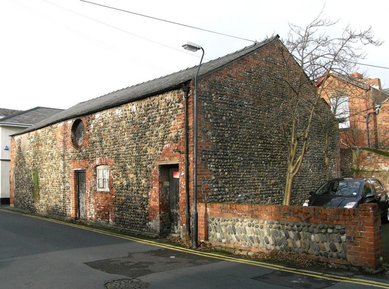
Stable, now store. Earlier C19, altered. Walls of cobble with red brick corners, some red brick bands to the gable wall and red brick surrounds to the openings; slate roof. Rectangular plan parallel to street. Two storeys and probably 4 structural bays, with a doorway in the centre, a large circular pitching hole above this, a small segmental-headed window to the right of the doorway and another doorway at the right-hand end. Included as a good example of local cobble-walled building, very few of which have survived.
Listing NGR: SD3676027149
External links are from the relevant listing authority and, where applicable, Wikidata. Wikidata IDs may be related buildings as well as this specific building. If you want to add or update a link, you will need to do so by editing the Wikidata entry.


Other nearby listed buildings