Approximate Location Map
Large Map »
Latitude: 51.8607 / 51°51'38"N
Longitude: -1.3028 / 1°18'10"W
OS Eastings: 448110
OS Northings: 218245
OS Grid: SP481182
Mapcode National: GBR 7WD.7FR
Mapcode Global: VHCX7.CHMF
Plus Code: 9C3WVM6W+7V
Entry Name: Rock of Gibraltar Public House
Listing Date: 26 February 1988
Grade: II
Source: Historic England
Source ID: 1220028
English Heritage Legacy ID: 393789
ID on this website: 101220028
Location: Enslow, Cherwell, Oxfordshire, OX5
County: Oxfordshire
District: Cherwell
Civil Parish: Bletchingdon
Traditional County: Oxfordshire
Lieutenancy Area (Ceremonial County): Oxfordshire
Church of England Parish: Bletchingdon
Church of England Diocese: Oxford
Tagged with: Pub
BLETCHINGDON
SP41NE
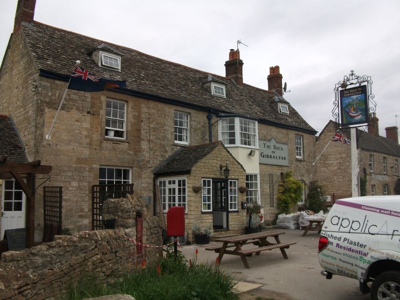
1/19 Rock of Gibraltar Public
House
GV II
Inn, now public house, Late C18. Squared and coursed limestone with ashlar
dressings; gabled stone slate roof, with old tile roof to rear wing; brick end
and ridge stacks, and end stack to rear wing of stone finished in brick. L-plan
with rear left wing. 2 storeys and attic; 4-window range. Gabled C20 porch to
left of centre. Two-storey canted bay window to centre, with glazing-bar
casements. Stone lintels over 6-pane sashes, and 8-pane sash to left; 3 hipped
roof dormers. Two-storey rear wing has C20 one-storey extension to left.
Stair-turret to centre of rear adjoins late C18 outshut to right. Interior;
light chamfered beams; first floor not inspected.
Listing NGR: SP4811018245
External links are from the relevant listing authority and, where applicable, Wikidata. Wikidata IDs may be related buildings as well as this specific building. If you want to add or update a link, you will need to do so by editing the Wikidata entry.


Other nearby listed buildings
