Approximate Location Map
Large Map »
Latitude: 50.6629 / 50°39'46"N
Longitude: -1.5831 / 1°34'59"W
OS Eastings: 429563
OS Northings: 84887
OS Grid: SZ295848
Mapcode National: GBR 67W.8LF
Mapcode Global: FRA 77KB.532
Plus Code: 9C2WMC78+5Q
Entry Name: Old Needles Battery
Listing Date: 28 March 1994
Grade: II
Source: Historic England
Source ID: 1220402
English Heritage Legacy ID: 393234
ID on this website: 101220402
Location: Isle of Wight, PO39
County: Isle of Wight
Civil Parish: Totland
Traditional County: Hampshire
Lieutenancy Area (Ceremonial County): Isle of Wight
Church of England Parish: Totland Bay Christ Church
Church of England Diocese: Portsmouth
Tagged with: Architectural structure Artillery battery
SZ38NW
1354-0/4/310
TOTLAND
Old Needles Battery
II
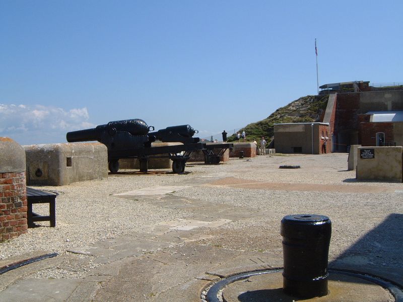
Former battery, now owned by National Trust as a museum. Built between 1861 and 1863 after the Royal Commission Review into the state of Britain's defences after France's first ironclad warship "La Gloire" was built. The old Needles Battery was one of a series of land forts, batteries and sea forts designed to protect Portsmouth and Southampton.
Built of brick with cement dressings. It is approached across a bridge with a cambered cement arch with keystone. Dated 1862 and brick walling. On the landward side the walls are of flint with brick lacing courses. The battery has six semi circular gun emplacements, a Laboratory, Guard Rooms and shell and cartridge stores. The barracks, officers quarters and artillery store have been demolished. The gun emplacements were enlarged to receive larger guns in 1869-75 and in 1875 but by the 1890s a new battery was built because it was feared that the more powerful modern guns might bring down the cliff and the Old Needles Battery became a practice battery. In 1899 a searchlight emplacement was built, a brick round-headed tunnel approached by a spiral staircase leading to a brick and cement emplacement.
Britain's first anti-aircraft gun was tested on the parade ground in 1913. Attached to the south is a c.1940 Signal Station (now used as a coastguard station) of red brick with metal casements.
Listing NGR: SZ2956384887
External links are from the relevant listing authority and, where applicable, Wikidata. Wikidata IDs may be related buildings as well as this specific building. If you want to add or update a link, you will need to do so by editing the Wikidata entry.


Other nearby listed buildings
