Approximate Location Map
Large Map »
Latitude: 50.6753 / 50°40'31"N
Longitude: -1.5299 / 1°31'47"W
OS Eastings: 433314
OS Northings: 86292
OS Grid: SZ333862
Mapcode National: GBR 792.J11
Mapcode Global: FRA 77P9.1T4
Plus Code: 9C2WMFGC+42
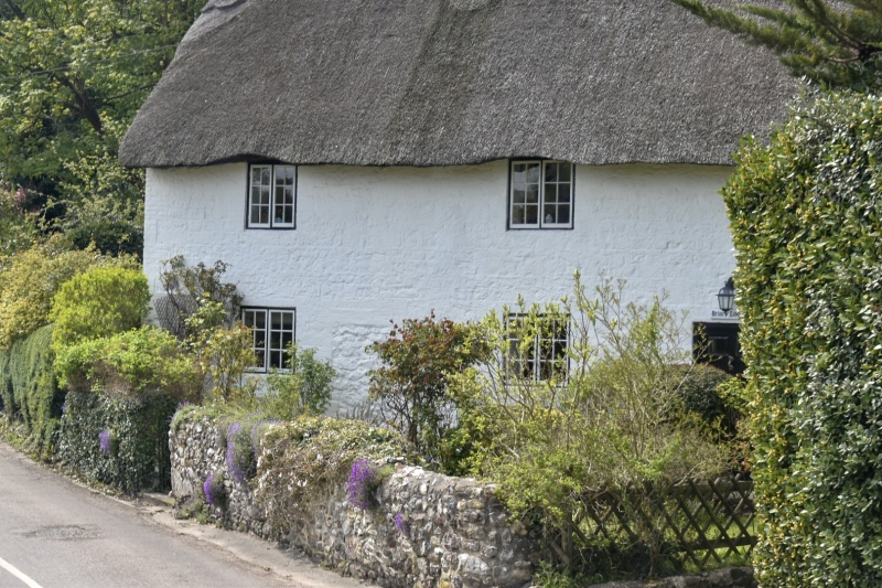
Entry Name: Briary Lodge
Listing Date: 28 March 1994
Grade: II
Source: Historic England
Source ID: 1220496
English Heritage Legacy ID: 393236
Also known as: Briary Cottage
ID on this website: 101220496
Location: Locksley, Isle of Wight, PO40
County: Isle of Wight
Civil Parish: Totland
Built-Up Area: Freshwater
Traditional County: Hampshire
Lieutenancy Area (Ceremonial County): Isle of Wight
Church of England Parish: Totland Bay Christ Church
Church of England Diocese: Portsmouth
Tagged with: Cottage Thatched cottage
TOTLAND
SZ38NW ALUM BAY OLD ROAD
1354-0/4/286 Briary Lodge
II
Formerly known as: Briary Cottage ALUM BAY OLD ROAD SHORWELL.
Cottage. C18. Built of stone rubble with brick dressings, now
painted. Thatched roof with 3 brick chimneystacks. 3 C19
casements. Simple doorcase.
Listing NGR: SZ3331486292
External links are from the relevant listing authority and, where applicable, Wikidata. Wikidata IDs may be related buildings as well as this specific building. If you want to add or update a link, you will need to do so by editing the Wikidata entry.


Other nearby listed buildings
