Approximate Location Map
Large Map »
Latitude: 53.5685 / 53°34'6"N
Longitude: -2.8854 / 2°53'7"W
OS Eastings: 341462
OS Northings: 408352
OS Grid: SD414083
Mapcode National: GBR 8W95.3J
Mapcode Global: WH86H.NK7P
Plus Code: 9C5VH497+9V
Entry Name: Buck I' TH' Vine Inn
Listing Date: 11 August 1972
Grade: II
Source: Historic England
Source ID: 1221077
English Heritage Legacy ID: 386366
Also known as: Buck i' th' Vine
Buck i' th' Vine, Ormskirk
ID on this website: 101221077
Location: Ormskirk, West Lancashire, L39
County: Lancashire
District: West Lancashire
Electoral Ward/Division: Scott
Parish: Non Civil Parish
Built-Up Area: Ormskirk
Traditional County: Lancashire
Lieutenancy Area (Ceremonial County): Lancashire
Church of England Parish: Ormskirk St Peter and St Paul
Church of England Diocese: Liverpool
SD4108SW
663-1/7/129
11/08/72
ORMSKIRK
BURSCOUGH STREET
(West side)
No.35
Buck i' th' Vine Inn
GV
II
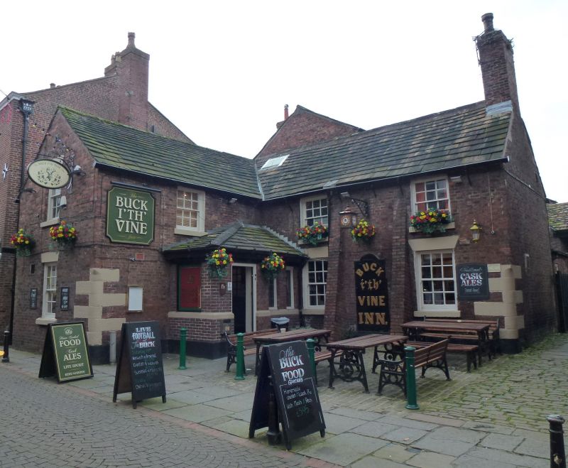
Public house. Probably late C17 or early C18, with C18 and C19
extensions and additions. Brown brick in English garden wall
bond, part with stone plinth, with some sandstone dressings
and stone slate roof. T-plan formed by main range parallel to
street and set back from it, with a projected wing and a back
extension both to the left. Two low storeys, 1:2 windows. The
2-window main range has 2 brick buttresses between the
windows, a vertical joint in the centre, 12-pane sashed
windows, all with raised sills and those at ground floor with
wedge lintels, and the right-hand corner rounded at ground
floor with protective stone quoins. The re-entrant has a C20
porch in the angle, and a 12-pane sashed window above this;
the gable of the wing has one window on each floor and a
rounded corner, like those of the main range. The rear has
various additions; and the back extension links with a much
longer and taller 2-storey range (of brick in Flemish bond)
which is said to contain at 1st floor a small former theatre
with minstrels gallery (not inspected). This range is attached
to the former barn at the west end of the courtyard (q.v.).
Listing NGR: SD4146208352
External links are from the relevant listing authority and, where applicable, Wikidata. Wikidata IDs may be related buildings as well as this specific building. If you want to add or update a link, you will need to do so by editing the Wikidata entry.


Other nearby listed buildings
