Latitude: 50.9848 / 50°59'5"N
Longitude: 0.4745 / 0°28'28"E
OS Eastings: 573781
OS Northings: 123512
OS Grid: TQ737235
Mapcode National: GBR PVN.0T5
Mapcode Global: FRA C6WH.W4K
Plus Code: 9F22XFMF+WR
Entry Name: The Grange
Listing Date: 13 May 1987
Grade: II
Source: Historic England
Source ID: 1221394
English Heritage Legacy ID: 413181
ID on this website: 101221394
Location: Robertsbridge, Rother, East Sussex, TN32
County: East Sussex
District: Rother
Civil Parish: Salehurst and Robertsbridge
Built-Up Area: Robertsbridge
Traditional County: Sussex
Lieutenancy Area (Ceremonial County): East Sussex
Church of England Parish: Salehurst St Mary
Church of England Diocese: Chichester
Tagged with: Building
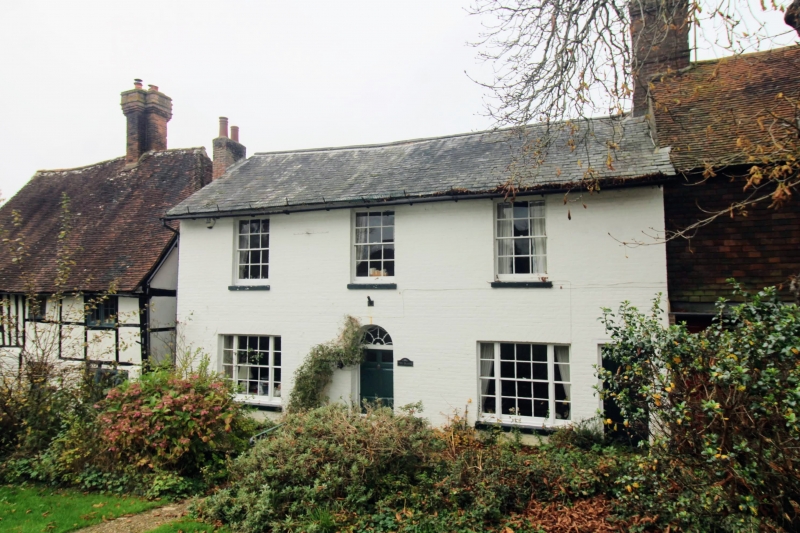
TQ 7223-7323 SALEHURST HIGH STREET,
Robertsbridge
42/29 (west side)
No 69 (The Grange)
GV II
Early C19 front to an older house. 2 storeys. 3 windows. Painted brick. Slate
roof. Glazing bars intact. Round-headed doorway with semi-circular fanlight.
Listing NGR: TQ7378123512
External links are from the relevant listing authority and, where applicable, Wikidata. Wikidata IDs may be related buildings as well as this specific building. If you want to add or update a link, you will need to do so by editing the Wikidata entry.


Other nearby listed buildings