Latitude: 51.0485 / 51°2'54"N
Longitude: 0.4225 / 0°25'20"E
OS Eastings: 569896
OS Northings: 130474
OS Grid: TQ698304
Mapcode National: GBR NSG.5MQ
Mapcode Global: FRA C6SB.SGX
Plus Code: 9F322CXC+9X
Entry Name: Dale Hill Farmhouse
Listing Date: 13 May 1987
Grade: II
Source: Historic England
Source ID: 1222287
English Heritage Legacy ID: 414426
ID on this website: 101222287
Location: Rother, East Sussex, TN5
County: East Sussex
District: Rother
Civil Parish: Ticehurst
Traditional County: Sussex
Lieutenancy Area (Ceremonial County): East Sussex
Church of England Parish: Ticehurst St Mary
Church of England Diocese: Chichester
Tagged with: Farmhouse
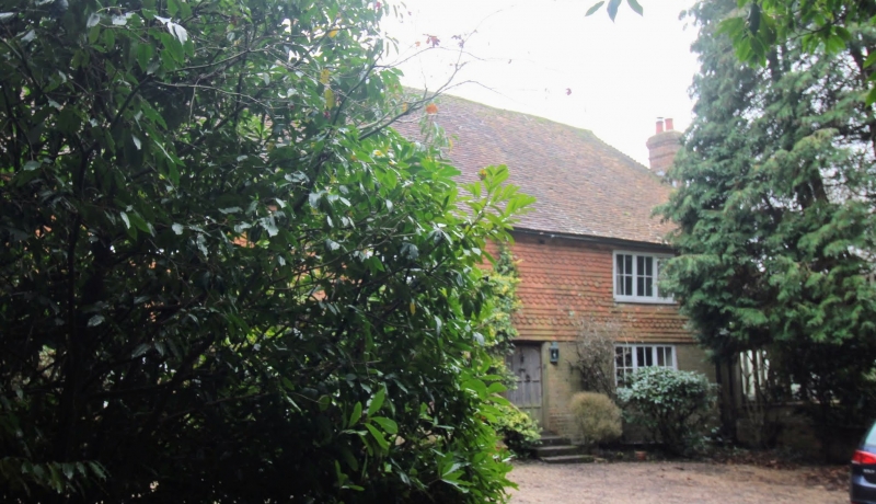
TQ 6830-6930 TICEHURST DALE HILL
34/52 Dale Hill Farmhouse
II
C18 or earlier. Two storeys. Three windows. Ground floor red brick, above
tile-hung. Tiled roof. Casement windows.
Listing NGR: TQ6989630474
External links are from the relevant listing authority and, where applicable, Wikidata. Wikidata IDs may be related buildings as well as this specific building. If you want to add or update a link, you will need to do so by editing the Wikidata entry.


Other nearby listed buildings