Latitude: 51.0458 / 51°2'45"N
Longitude: 0.4093 / 0°24'33"E
OS Eastings: 568984
OS Northings: 130150
OS Grid: TQ689301
Mapcode National: GBR NSG.89P
Mapcode Global: FRA C6RC.19D
Plus Code: 9F322CW5+8P
Entry Name: The Granary
Listing Date: 23 December 1986
Grade: II
Source: Historic England
Source ID: 1222444
English Heritage Legacy ID: 414582
ID on this website: 101222444
Location: Ticehurst, Rother, East Sussex, TN5
County: East Sussex
District: Rother
Civil Parish: Ticehurst
Built-Up Area: Ticehurst
Traditional County: Sussex
Lieutenancy Area (Ceremonial County): East Sussex
Church of England Parish: Ticehurst St Mary
Church of England Diocese: Chichester
Tagged with: Appendage
This list entry was subject to a Minor Amendment on 4 November 2024 to amend the name and address and reformat the text to current standards.
TQ 6830-6930
34/27A
TICEHURST
ST MARY'S LANE
The Granary
(Formerly listed as Outbuilding in the grounds of the Long House to the south west of the house, HIGH STREET)
23/12/86
GV
II
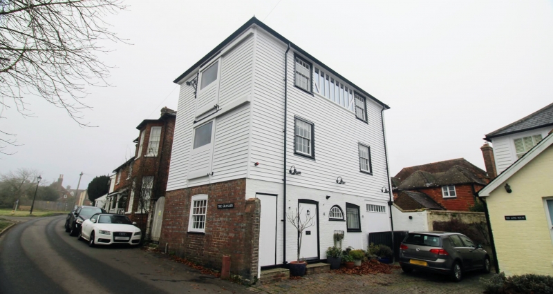
This building fronts onto St Mary's Lane. Originally stables with store-rooms over. Early C19. Three storeys. Two windows. Ground floor red brick, above faced with weatherboarding. Hipped slate roof. Glazing bars intact. Hoist on south wall.
Listing NGR: TQ6898430150
External links are from the relevant listing authority and, where applicable, Wikidata. Wikidata IDs may be related buildings as well as this specific building. If you want to add or update a link, you will need to do so by editing the Wikidata entry.


Other nearby listed buildings