Latitude: 50.8572 / 50°51'26"N
Longitude: -0.0207 / 0°1'14"W
OS Eastings: 539405
OS Northings: 108280
OS Grid: TQ394082
Mapcode National: GBR KQ7.1LJ
Mapcode Global: FRA B6VT.V21
Plus Code: 9C2XVX4H+VP
Entry Name: Rough Down
Listing Date: 27 September 1979
Grade: II
Source: Historic England
Source ID: 1222589
English Heritage Legacy ID: 414818
ID on this website: 101222589
Location: Kingston near Lewes, Lewes, East Sussex, BN7
County: East Sussex
District: Lewes
Civil Parish: Kingston near Lewes
Built-Up Area: Kingston near Lewes
Traditional County: Sussex
Lieutenancy Area (Ceremonial County): East Sussex
Church of England Parish: Kingston St Pancras
Church of England Diocese: Chichester
Tagged with: Architectural structure
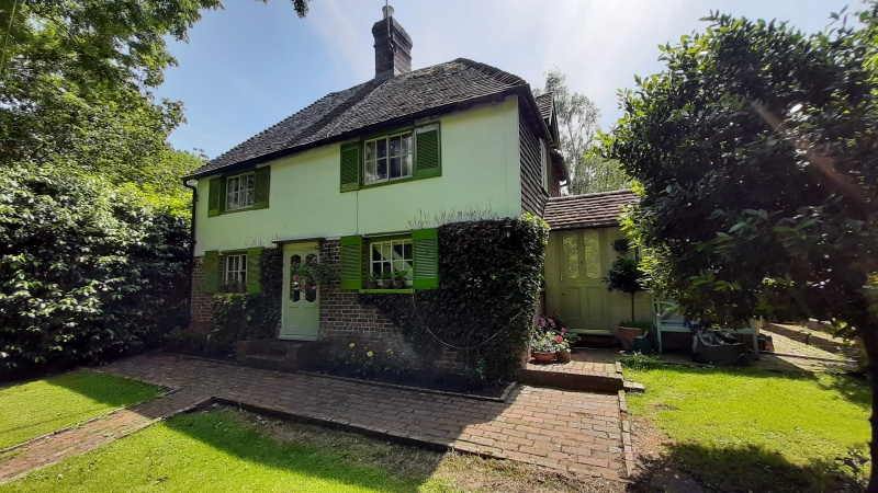
KINGSTON NEAR LEWES THE STREET
1.
5206
(south-east side)
Rough Down
TQ 3908 23/358
II
2.
C18. Two storeys. Two windows. Ground floor red brick, above stuccoed.
Hipped tiled roof. Horzontally-sliding sash windows.
Listing NGR: TQ3940508280
External links are from the relevant listing authority and, where applicable, Wikidata. Wikidata IDs may be related buildings as well as this specific building. If you want to add or update a link, you will need to do so by editing the Wikidata entry.


Other nearby listed buildings