Latitude: 51.5149 / 51°30'53"N
Longitude: -0.1979 / 0°11'52"W
OS Eastings: 525142
OS Northings: 181090
OS Grid: TQ251810
Mapcode National: GBR C8.8SJ
Mapcode Global: VHGQY.J670
Plus Code: 9C3XGR72+XR
Entry Name: 162 and 164, Westbourne Grove W11
Listing Date: 1 December 1987
Grade: II
Source: Historic England
Source ID: 1222707
English Heritage Legacy ID: 207555
ID on this website: 101222707
Location: Notting Hill, Westminster, London, W11
County: London
District: City of Westminster
Electoral Ward/Division: Bayswater
Parish: Non Civil Parish
Built-Up Area: Kensington and Chelsea
Traditional County: Middlesex
Lieutenancy Area (Ceremonial County): Greater London
Church of England Parish: St Peter Notting Hill
Church of England Diocese: London
Tagged with: Building
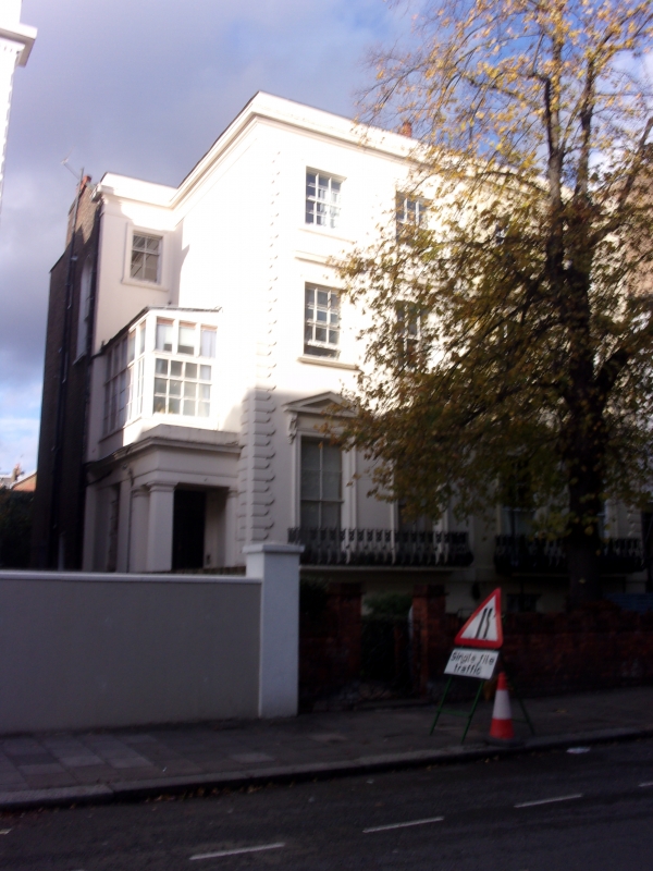
TQ 2581 SW CITY OF WESTMINSTER WESTBOURNE GROVE, W11
49/20 (north side)
Nos 162 and 164
GV II
Semidetached houses. Circa 1845. Stucco. Roof not visible. Rusticated quoins.
3 storeys and basement, 2 windows wide with extra recessed bays to outside with
recessed entrances in pilastered porches. Panelled doors. Square headed windows
pedimented to ground floor and corniced to first floor. Sashes, glazing bars.
Casements to second floor. Bombé balconies to ground floor. Cornice above
second floor; parapet.
Listing NGR: TQ2514281090
External links are from the relevant listing authority and, where applicable, Wikidata. Wikidata IDs may be related buildings as well as this specific building. If you want to add or update a link, you will need to do so by editing the Wikidata entry.


Other nearby listed buildings