Approximate Location Map
Large Map »
Latitude: 51.4904 / 51°29'25"N
Longitude: -0.1624 / 0°9'44"W
OS Eastings: 527672
OS Northings: 178429
OS Grid: TQ276784
Mapcode National: GBR 7M.QX
Mapcode Global: VHGQZ.4SHT
Plus Code: 9C3XFRRQ+52
Entry Name: 110 and 112, King's Road SW3
Listing Date: 22 September 1971
Grade: II
Source: Historic England
Source ID: 1224736
English Heritage Legacy ID: 420865
ID on this website: 101224736
Location: Chelsea, Kensington and Chelsea, London, SW3
County: London
District: Kensington and Chelsea
Electoral Ward/Division: Royal Hospital
Parish: Non Civil Parish
Built-Up Area: Kensington and Chelsea
Traditional County: Middlesex
Lieutenancy Area (Ceremonial County): Greater London
Church of England Parish: St Luke and Christ Church Chelsea
Church of England Diocese: London
Tagged with: Building
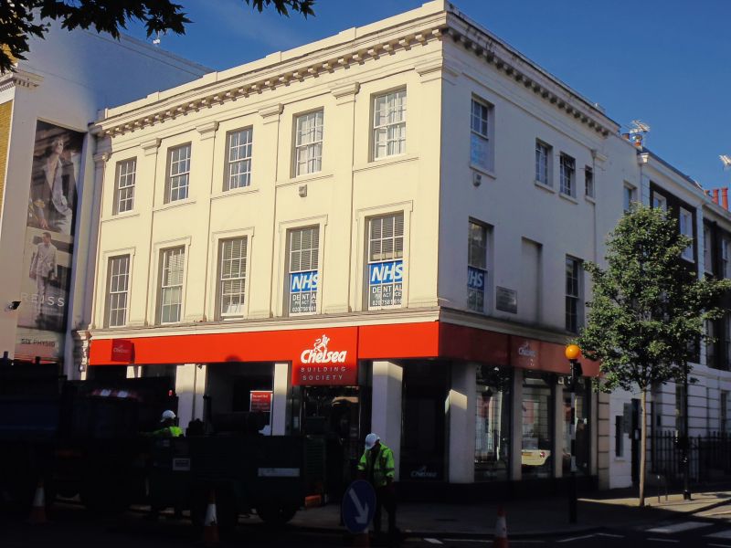
TQ 2778 SE KING'S ROAD SW3
57/4 (north side)
22.9.71 Nos 110 and 112
GV
II
Houses with shops below. Mid C19. Stucco. Three storeys. Five bays wide altogether.
Doric pilasters to first and second storeys. Part of a long, ambitious development in
3 blocks to King's Road, and related to development in Lincoln, Coulsdon and Anderson
Streets.
Listing NGR: TQ2767278429
External links are from the relevant listing authority and, where applicable, Wikidata. Wikidata IDs may be related buildings as well as this specific building. If you want to add or update a link, you will need to do so by editing the Wikidata entry.


Other nearby listed buildings
