Approximate Location Map
Large Map »
Latitude: 50.5972 / 50°35'49"N
Longitude: -1.2008 / 1°12'2"W
OS Eastings: 456661
OS Northings: 77797
OS Grid: SZ566777
Mapcode National: GBR 9F4.H71
Mapcode Global: FRA 87CH.B0P
Plus Code: 9C2WHQWX+VM
Entry Name: Mulberry Grange
Listing Date: 15 July 1976
Grade: II
Source: Historic England
Source ID: 1225260
English Heritage Legacy ID: 421553
ID on this website: 101225260
Location: Cowlease, Isle of Wight, PO38
County: Isle of Wight
Civil Parish: Ventnor
Built-Up Area: Ventnor
Traditional County: Hampshire
Lieutenancy Area (Ceremonial County): Isle of Wight
Church of England Parish: Ventnor Holy Trinity
Church of England Diocese: Portsmouth
Tagged with: Building
ST BONIFACE ROAD
1.
5271
(South Side)
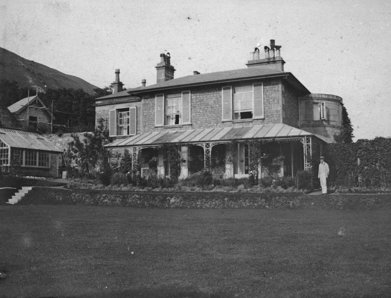
Mulberry Grange
SZ 5677 2/141
II
2.
Circa 1840-50 villa. 2 storeys crazed rubble with tooled ashlar quoins. Basement.
Hipped slate roof with flat eaves. East entrance front of 3 windows, centre false,
glazing bar sashes, the left hand window altered to glazed door with wood steps
up to 1st floor. Enclosed tooled ashlar porch with pilasters and cornice - panelled
and glazed door. Slightly recessed coach house extension to right hand, frieze,
cornice and blocking course; 1 window in rendered rusticated surround above blocked,
segmental carriage archway on ground floor. South front above terraced garden,
has prominent, tooled ashlar, bowed projection to right hand of 3 windows, glazing
bar sashes, the side ones smaller with marginal glazing. Round moulded string
course over ground floor, similarly moulded cornice and blocking course. Simple
window bay to left hand.
Listing NGR: SZ5666177797
External links are from the relevant listing authority and, where applicable, Wikidata. Wikidata IDs may be related buildings as well as this specific building. If you want to add or update a link, you will need to do so by editing the Wikidata entry.


Other nearby listed buildings
