Approximate Location Map
Large Map »
Latitude: 51.5114 / 51°30'41"N
Longitude: -0.1948 / 0°11'41"W
OS Eastings: 525365
OS Northings: 180707
OS Grid: TQ253807
Mapcode National: GBR 0D.GC
Mapcode Global: VHGQY.K8VQ
Plus Code: 9C3XGR64+H3
Entry Name: 12, Pembridge Square W2
Listing Date: 15 April 1969
Grade: II
Source: Historic England
Source ID: 1225823
English Heritage Legacy ID: 422801
ID on this website: 101225823
Location: Notting Hill, Kensington and Chelsea, London, W2
County: London
District: Kensington and Chelsea
Electoral Ward/Division: Pembridge
Parish: Non Civil Parish
Built-Up Area: Kensington and Chelsea
Traditional County: Middlesex
Lieutenancy Area (Ceremonial County): Greater London
Church of England Parish: St Peter Notting Hill
Church of England Diocese: London
Tagged with: Building
TQ 2580 NW PEMBRIDGE SQUARE W2
20/23 (south side)
15.4.69 No 12
GV
II
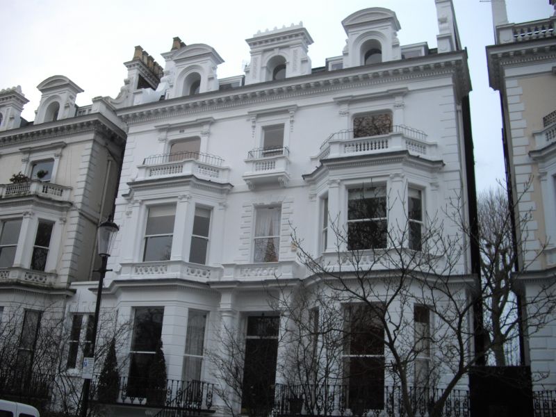
Large, detached house. Mid C19. Stucco. Three windows wide; three storeys plus
basement and attic. Florid classical manner. Central entrance with two storey canted
bay windows to each side. Elaborate dormers. (cf Holland Park)
Forms part of unified scheme with Nos 6-11 and 13-35 (consec) Pembridge Square
(Nos 19-22 are in Westminster).
External links are from the relevant listing authority and, where applicable, Wikidata. Wikidata IDs may be related buildings as well as this specific building. If you want to add or update a link, you will need to do so by editing the Wikidata entry.


Other nearby listed buildings
