Approximate Location Map
Large Map »
Latitude: 53.9045 / 53°54'16"N
Longitude: -1.4423 / 1°26'32"W
OS Eastings: 436738
OS Northings: 445520
OS Grid: SE367455
Mapcode National: GBR LRC9.J2
Mapcode Global: WHDB5.T4C1
Plus Code: 9C5WWH35+R3
Entry Name: Milestone Approximately 60 Metres East of Junction with Lane to Moor Farm
Listing Date: 22 July 1986
Grade: II
Source: Historic England
Source ID: 1225902
English Heritage Legacy ID: 422843
ID on this website: 101225902
Location: Leeds, West Yorkshire, LS17
County: Leeds
Civil Parish: East Keswick
Traditional County: Yorkshire
Lieutenancy Area (Ceremonial County): West Yorkshire
Church of England Parish: Collingham St Oswald with Harewood
Church of England Diocese: Leeds
Tagged with: Milestone
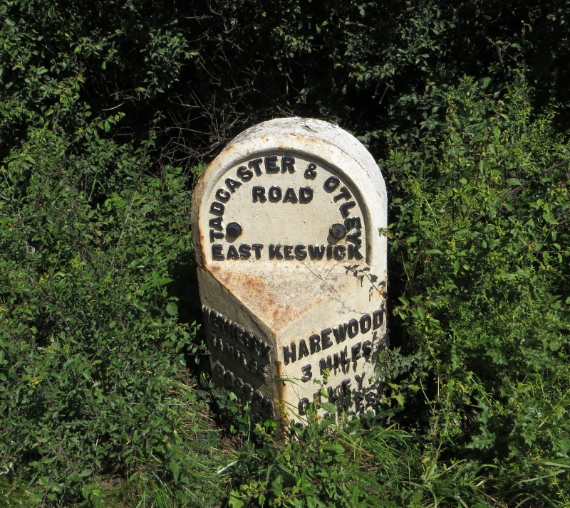
EAST KESWICK HAREWOOD ROAD
SE34NE LS17 (north side)
SE367455
3/48 Milestone approx. 60m
east of junction with
lane to Moor Farm
II
Milestone. Mid C19. Arched stone overlaid with cast-iron triangular in section,
letters in relief.
Top reads: "TADCASTER & OTLEY
ROAD
EAST KESWICK
Left face: WETHERBY HAREWOOD Right face:
3¼ MILES 3 MILES
BOSTON OTLEY
4 MILES 11¼ MILES
TADCASTER
8 MILES
Listing NGR: SE3673845520
External links are from the relevant listing authority and, where applicable, Wikidata. Wikidata IDs may be related buildings as well as this specific building. If you want to add or update a link, you will need to do so by editing the Wikidata entry.


Other nearby listed buildings
