Approximate Location Map
Large Map »
Latitude: 53.9014 / 53°54'5"N
Longitude: -1.5116 / 1°30'41"W
OS Eastings: 432186
OS Northings: 445136
OS Grid: SE321451
Mapcode National: GBR KRWB.J6
Mapcode Global: WHC90.R6CG
Plus Code: 9C5WWF2Q+H9
Entry Name: Harewood Arms Public House
Listing Date: 30 March 1966
Grade: II
Source: Historic England
Source ID: 1226256
English Heritage Legacy ID: 423440
ID on this website: 101226256
Location: Harewood, Leeds, West Yorkshire, LS17
County: Leeds
Civil Parish: Harewood
Traditional County: Yorkshire
Lieutenancy Area (Ceremonial County): West Yorkshire
Church of England Parish: Collingham St Oswald with Harewood
Church of England Diocese: Leeds
Tagged with: Pub
This list entry was subject to a Minor Amendment on 23 July 2021 to reformat text to current standards
SE3245
14/110
HAREWOOD
HARROGATE ROAD (east side) LS17
Harewood Arms Public House
30.3.66
GV
II
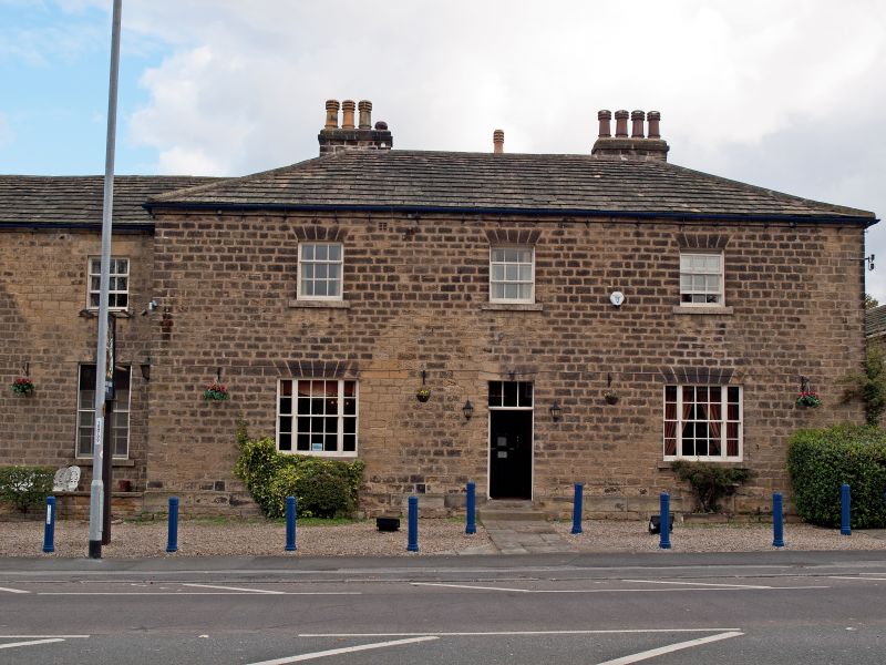
Public house. Probably early C 19. Hammer-dressed stone, stone slate roof. L-shaped plan. Two storeys, six bays, three right-hand bays breaking forward, rear wing to left. Ashlar plinth. All windows flat-arched with voussoirs and projecting sills. Three left-hand bays have twenty-pane sash windows with smaller nine-pane sashes above. Right-hand bays have central doorway with overlight and lintel cut with false voussoirs flanked by tripartite sashes with three smaller nine-pane sashes above. Projecting eaves band. Hipped roofs. Three stacks to rear pitch of right block.
Right-hand return: central doorway with tri-partite sash to right and twelve-pane sash to left with nine-pane sashes above. Left-hand return has single bay with tall French window and sash above. Slightly set back to left is six-bay wing with sixteen-pane sashes and square twelve-pane sashes above all with monolithic lintels cut with false voussoirs. Sixth bay altered with wide double-door entrance. Two ridge stacks to this range.
Listing NGR: SE3218645136
External links are from the relevant listing authority and, where applicable, Wikidata. Wikidata IDs may be related buildings as well as this specific building. If you want to add or update a link, you will need to do so by editing the Wikidata entry.


Other nearby listed buildings
