Approximate Location Map
Large Map »
Latitude: 51.4864 / 51°29'11"N
Longitude: -0.1595 / 0°9'34"W
OS Eastings: 527889
OS Northings: 177990
OS Grid: TQ278779
Mapcode National: GBR 8P.CB
Mapcode Global: VHGQZ.6W1W
Plus Code: 9C3XFRPR+H6
Entry Name: Second Lodge to South of Stable Yard, Royal Hospital
Listing Date: 15 April 1969
Grade: II
Source: Historic England
Source ID: 1226382
English Heritage Legacy ID: 423624
ID on this website: 101226382
Location: Chelsea, Kensington and Chelsea, London, SW3
County: London
District: Kensington and Chelsea
Electoral Ward/Division: Royal Hospital
Parish: Non Civil Parish
Built-Up Area: Kensington and Chelsea
Traditional County: Middlesex
Lieutenancy Area (Ceremonial County): Greater London
Church of England Parish: St Luke and Christ Church Chelsea
Church of England Diocese: London
Tagged with: Architectural structure
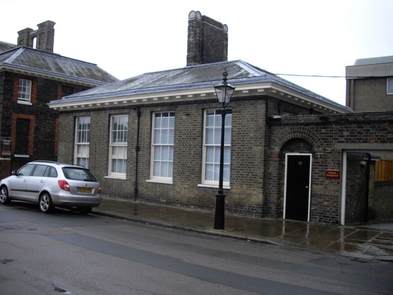
TQ 2777 NE ROYAL HOSPITAL ROAD SW3
63/49
15.4.69 Second lodge to south of
stable yard, Royal Hospital
GV
II
Early C19 lodge. Yellow brick. One storey, 4 windows wide, with sashes retaining
glazing bars. Timber eaves cornice. Hipped slate roof to eaves. Designed to match
adjacent lodge to right.
Listing NGR: TQ2788977990
External links are from the relevant listing authority and, where applicable, Wikidata. Wikidata IDs may be related buildings as well as this specific building. If you want to add or update a link, you will need to do so by editing the Wikidata entry.


Other nearby listed buildings
