Approximate Location Map
Large Map »
Latitude: 51.5104 / 51°30'37"N
Longitude: -0.2114 / 0°12'40"W
OS Eastings: 524219
OS Northings: 180570
OS Grid: TQ242805
Mapcode National: GBR BF.KCV
Mapcode Global: VHGQY.993G
Plus Code: 9C3XGQ6Q+5C
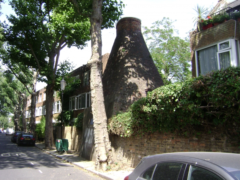
Entry Name: Pottery Kiln
Listing Date: 7 November 1984
Grade: II
Source: Historic England
Source ID: 1227066
English Heritage Legacy ID: 424659
ID on this website: 101227066
Location: Notting Hill, Kensington and Chelsea, London, W11
County: London
District: Kensington and Chelsea
Electoral Ward/Division: Notting Dale
Parish: Non Civil Parish
Built-Up Area: Kensington and Chelsea
Traditional County: Middlesex
Lieutenancy Area (Ceremonial County): Greater London
Church of England Parish: St John Ladbrook Grove
Church of England Diocese: London
TQ 2480 NW WALMER ROAD W11
18/1
Pottery Kiln
II
Former pottery kiln. Now a dwellinghouse. Rebuilt 1879. Brick, cone shaped. Sole
surviving tile kiln relating to "The Potteries" established during the 1830s between
Clarendon Road and Latimer Road.
Listing NGR: TQ2421980570
External links are from the relevant listing authority and, where applicable, Wikidata. Wikidata IDs may be related buildings as well as this specific building. If you want to add or update a link, you will need to do so by editing the Wikidata entry.


Other nearby listed buildings
