Approximate Location Map
Large Map »
Latitude: 52.0626 / 52°3'45"N
Longitude: -2.2182 / 2°13'5"W
OS Eastings: 385139
OS Northings: 240487
OS Grid: SO851404
Mapcode National: GBR 1HP.Q0D
Mapcode Global: VH93D.HFP6
Plus Code: 9C4V3Q7J+2P
Entry Name: 20, Old Street
Listing Date: 27 July 1983
Grade: II
Source: Historic England
Source ID: 1227192
English Heritage Legacy ID: 424839
ID on this website: 101227192
Location: Upton upon Severn, Malvern Hills, Worcestershire, WR8
County: Worcestershire
District: Malvern Hills
Civil Parish: Upton-upon-Severn
Built-Up Area: Upton upon Severn
Traditional County: Worcestershire
Lieutenancy Area (Ceremonial County): Worcestershire
Church of England Parish: Upton-on-Severn
Church of England Diocese: Worcester
Tagged with: Building
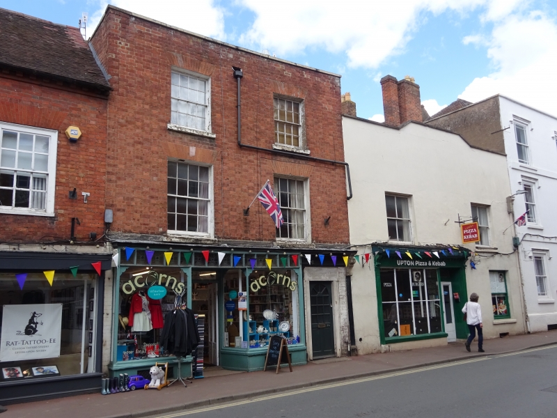
UPTON-UPON-SEVERN OLD STREET
SO 8540
2/72 (west side)
No 20
GV
II
Later C18 red brick house. Three-storey and parapet. Plain tile valley roof. Two
window range with sliding sashes and glazing bars. Gauged brick window heads.
Altered C19 shopfront. Two gables to rear.
Listing NGR: SO8513940487
External links are from the relevant listing authority and, where applicable, Wikidata. Wikidata IDs may be related buildings as well as this specific building. If you want to add or update a link, you will need to do so by editing the Wikidata entry.


Other nearby listed buildings
