Latitude: 50.7336 / 50°44'0"N
Longitude: -2.7616 / 2°45'41"W
OS Eastings: 346348
OS Northings: 92942
OS Grid: SY463929
Mapcode National: GBR PP.0B3P
Mapcode Global: FRA 5734.MXN
Plus Code: 9C2VP6MQ+C9
Entry Name: 10-16, St Michael's Lane
Listing Date: 19 September 1975
Grade: II
Source: Historic England
Source ID: 1227774
English Heritage Legacy ID: 402217
ID on this website: 101227774
Location: Bridport, Dorset, DT6
County: Dorset
Civil Parish: Bridport
Built-Up Area: Bridport
Traditional County: Dorset
Lieutenancy Area (Ceremonial County): Dorset
Church of England Parish: Bridport St Mary
Church of England Diocese: Salisbury
Tagged with: Building
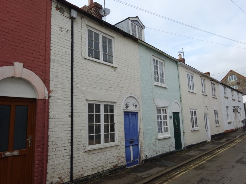
1.
5191 ST MICHAEL'S LANE
(West Side)
Nos 10 to 16 (even)
SY 4692 3/395
II
2.
Early C19. Red brick. Pitched slate roof. Red brick stacks. 2 storeys.
4 ranges of casements, only No 12's with original glazing bars. 3 modern doors
with blind semi-circular fanlights.
Listing NGR: SY4634892942
External links are from the relevant listing authority and, where applicable, Wikidata. Wikidata IDs may be related buildings as well as this specific building. If you want to add or update a link, you will need to do so by editing the Wikidata entry.


Other nearby listed buildings