Latitude: 51.9412 / 51°56'28"N
Longitude: -0.8829 / 0°52'58"W
OS Eastings: 476890
OS Northings: 227557
OS Grid: SP768275
Mapcode National: GBR BZY.CM0
Mapcode Global: VHDTJ.NG4Q
Plus Code: 9C3XW4R8+FV
Entry Name: The Bakery
Listing Date: 29 May 1984
Grade: II
Source: Historic England
Source ID: 1228587
English Heritage Legacy ID: 403239
Also known as: The Bakery and 10 Horn Street
ID on this website: 101228587
Location: Winslow, Buckinghamshire, MK18
County: Buckinghamshire
Civil Parish: Winslow
Built-Up Area: Winslow
Traditional County: Buckinghamshire
Lieutenancy Area (Ceremonial County): Buckinghamshire
Church of England Parish: Winslow
Church of England Diocese: Oxford
Tagged with: Architectural structure Thatched cottage
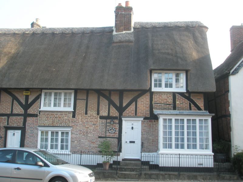
SP 7627 NE WINSLOW HORN STREET
(north side)
7/173 No. 8 (The Bakery) and No. 10
-
GV II
Bakery and house. Early C17 part of 3 bays to right, extended one bay to
left late C17. Timber frame with curved braces, brick infill, colourwashed
to left gable, and rendered plinth. Thatch roof, half-hipped to left,
chimney stack of thin brick between right-hand bays, another stack to
rear between left-hand bays. 2 storeys and attic. Barred wooden casements.
Ground floor outer bays have early C20 square bay windows. 3-light
casements to first floor and centre bays, those to ground floor centre
with moulded wooden cornices. First floor right-hand window in thatch,
3-light leaded dormer window in second bay. 4-panel door to centre in
moulded surround with cornice. 2 other doors with moulded cornices
between right hand bays. Late C19 brick service block to rear.
RCHM II p 344 MON 14
Listing NGR: SP7688827559
External links are from the relevant listing authority and, where applicable, Wikidata. Wikidata IDs may be related buildings as well as this specific building. If you want to add or update a link, you will need to do so by editing the Wikidata entry.


Other nearby listed buildings