Approximate Location Map
Large Map »
Latitude: 50.8382 / 50°50'17"N
Longitude: -1.115 / 1°6'54"W
OS Eastings: 462411
OS Northings: 104667
OS Grid: SU624046
Mapcode National: GBR VM6.DP
Mapcode Global: FRA 86KW.FF8
Plus Code: 9C2WRVQM+7X
Entry Name: Portchester Castle
Listing Date: 18 October 1955
Grade: I
Source: Historic England
Source ID: 1229190
English Heritage Legacy ID: 141469
ID on this website: 101229190
Location: Fareham, Hampshire, PO16
County: Hampshire
District: Fareham
Electoral Ward/Division: Portchester East
Parish: Non Civil Parish
Built-Up Area: Portsmouth
Traditional County: Hampshire
Lieutenancy Area (Ceremonial County): Hampshire
Church of England Parish: Portchester St Mary
Church of England Diocese: Portsmouth
Tagged with: Castle Archaeological site
CASTLE STREET
1.
5231
(South End)
Portchester
Portchester Castle
SU 6204 11/203 18.10.55.
I GV
2.
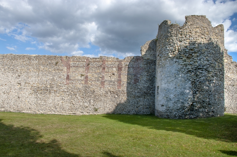
A Scheduled A.M, in the care of the Department of the Environment. The main walls are those of the Roman fort Portus Adurni built in the late C3 or early C4. They form a square 200 yds wide and enclose between 8 and 9 acres. They are of flints with bonding courses of brick or stone, but have been substantially repaired in the mediaeval period. Originally there were hollow semi-circular bastions in the angles and 4 on each side. Of these 20 bastions, 14 survive. The entrances were in the centre of the west and east sides, but the gateways now standing are both mediaeval. Of the west or land gate, the lower storey is C12, ashlar, with a 3-centred archway and originally stone vaulting to the roof but this has mostly fallen away.
The upper portion is C14, stone rubble, and has 1 window containing 2 tiers of
3 lights on the inner side and 2 corbel heads above the cornice. The east or watergate is a shell divided into 2 sections with an archway between. It is faced with ashlar.
The outer portion is C14 and has a portcullis groove to the archway. The inner
portion is older and has a circular turret staircase in the south west corner.
In the north west corner of the Roman fort a mediaeval castle was built in the
reign of Henry II with a massive keep in the angle of the Roman walls, which were
cut away by a surrounding wall on the east and south sides forming an inner bailey with a projecting tower in the south east corner and a gateway in the south wall with a moat to the south and east filled with water at high tide by a sluice in the Roman wall. The keep, which projects beyond the Roman walls, is intact. It is 40 ft square and the walls are 8 ft thick. The 3 original storeys were built about 1160 and the 4th storey added in the early C13. The remaining buildings are now ruined. Those along the west and south walls of the inner bailey and Assheton's Tower in the north west corner were erected in the C14 and those to the south of the latter along the west wall in the C17. Photographs in the N.M.R. and article in Country Life, Volume 75.
Portchester Castle forms a group with St Mary's Church, the Churchyard walls, the
lamp in the Churchyard and the lychgate.
Listing NGR: SU6222404655
External links are from the relevant listing authority and, where applicable, Wikidata. Wikidata IDs may be related buildings as well as this specific building. If you want to add or update a link, you will need to do so by editing the Wikidata entry.


Other nearby listed buildings
