Approximate Location Map
Large Map »
Latitude: 51.2292 / 51°13'45"N
Longitude: -0.3326 / 0°19'57"W
OS Eastings: 516522
OS Northings: 149104
OS Grid: TQ165491
Mapcode National: GBR HGJ.SWM
Mapcode Global: VHGS7.6C1J
Plus Code: 9C3X6MH8+MX
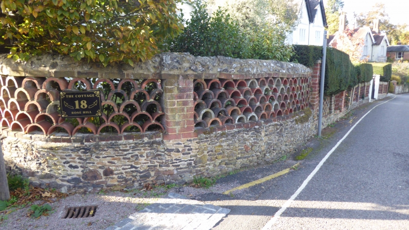
Entry Name: Garden Wall to No 18
Listing Date: 11 June 1973
Grade: II
Source: Historic England
Source ID: 1229462
English Heritage Legacy ID: 404283
ID on this website: 101229462
Location: Rose Hill, Mole Valley, Surrey, RH4
County: Surrey
District: Mole Valley
Electoral Ward/Division: Dorking South
Parish: Non Civil Parish
Built-Up Area: Dorking
Traditional County: Surrey
Lieutenancy Area (Ceremonial County): Surrey
Church of England Parish: Dorking St Paul
Church of England Diocese: Guildford
Tagged with: Wall
ROSE HILL
1.
1049
Garden Wall to
TQ 1649 SE 1/177A
No 18
II
2.
Wall with sandstone rubble base with brick pilasters and with infilling of
pierced panels of red tiled in Italian manner above, brick gate piers.
Listing NGR: TQ1652249104
External links are from the relevant listing authority and, where applicable, Wikidata. Wikidata IDs may be related buildings as well as this specific building. If you want to add or update a link, you will need to do so by editing the Wikidata entry.


Other nearby listed buildings
