Latitude: 52.9233 / 52°55'23"N
Longitude: -1.4789 / 1°28'43"W
OS Eastings: 435132
OS Northings: 336331
OS Grid: SK351363
Mapcode National: GBR PJF.XG
Mapcode Global: WHDGT.8S0B
Plus Code: 9C4WWGFC+8F
Entry Name: 19-20, Sadler Gate
Listing Date: 24 February 1977
Grade: II
Source: Historic England
Source ID: 1229465
English Heritage Legacy ID: 404286
ID on this website: 101229465
Location: Derby, Derbyshire, DE1
County: City of Derby
Electoral Ward/Division: Arboretum
Parish: Non Civil Parish
Built-Up Area: Derby
Traditional County: Derbyshire
Lieutenancy Area (Ceremonial County): Derbyshire
Church of England Parish: Derby St Alkmund and St Werburgh
Church of England Diocese: Derby
Tagged with: Building
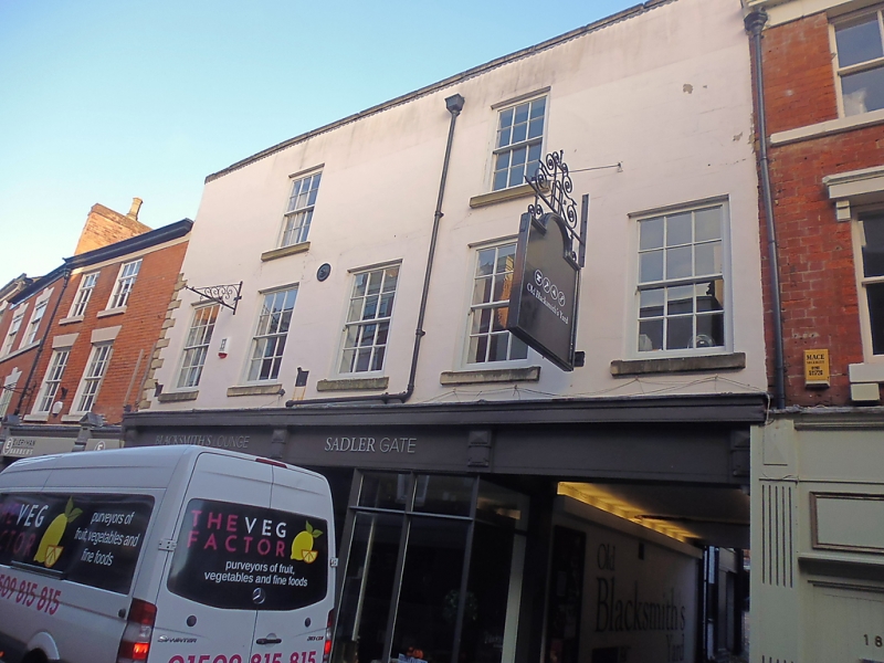
SADLER GATE
1.
5170
(North Side)
Nos 19 and 20
SK 3536 SW 1/264
II GV
2.
Early Cl9. Engraved stucco; 3 storeys; 5 sash windows; quoins on left-hand side;
stone-coped parapet. Square-headed covered way under on right-hand side; modern
shop fronts. Included for group value.
Nos 19 to 25 (consec) form a group.
Listing NGR: SK3512836334
External links are from the relevant listing authority and, where applicable, Wikidata. Wikidata IDs may be related buildings as well as this specific building. If you want to add or update a link, you will need to do so by editing the Wikidata entry.


Other nearby listed buildings