Approximate Location Map
Large Map »
Latitude: 51.5198 / 51°31'11"N
Longitude: -0.1476 / 0°8'51"W
OS Eastings: 528618
OS Northings: 181726
OS Grid: TQ286817
Mapcode National: GBR C9.1C
Mapcode Global: VHGQZ.D2B7
Plus Code: 9C3XGV92+WX
Entry Name: 77, Harley Street W1
Listing Date: 10 September 1954
Grade: II*
Source: Historic England
Source ID: 1230076
English Heritage Legacy ID: 210110
ID on this website: 101230076
Location: Marylebone, Westminster, London, W1G
County: London
District: City of Westminster
Electoral Ward/Division: Marylebone High Street
Parish: Non Civil Parish
Built-Up Area: City of Westminster
Traditional County: Middlesex
Lieutenancy Area (Ceremonial County): Greater London
Church of England Parish: St Marylebone
Church of England Diocese: London
Tagged with: Building
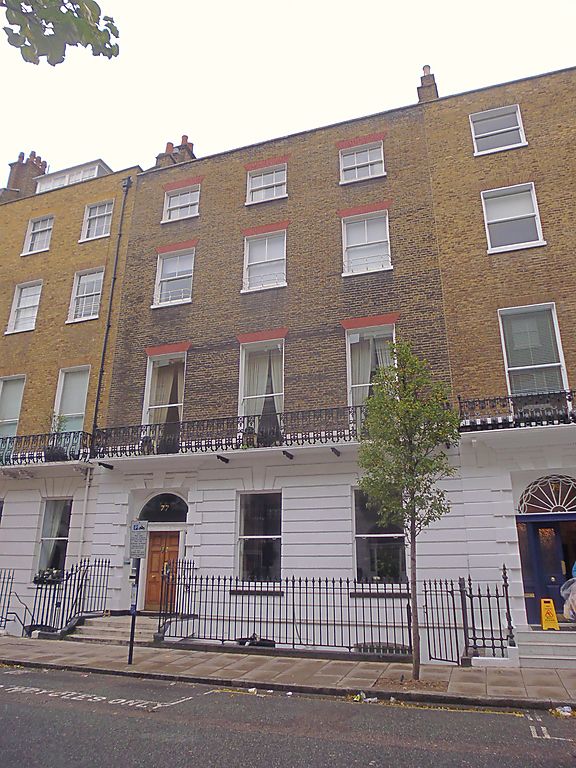
TQ 2881 NE CITY OF WESTMINSTER HARLEY STREET, Wl
45/60 (West side)
10.9.54 No. 77
G.V. II*
Terraced town house, c.1774-80 Portland Estate development by John White
in partnership with the plasterer Thomas Collins (associates of Chambers).
Stock brick with rusticated stucco ground floor; concealed slate roof. 4
storeys and basement. 3 windows wide. Square headed doorway to left, in
Coade stone vermiculated Gibbs surround; panelled door, sidelights and
fanlight. Recessed sashes, under flat gauged arches to upper floors.
Stuccowork finished off with plat band. Dentil cornice below parapet with
coping. Cast iron early C.l9 balcony across 1st floor. Cast iron area
railings with urn finials. Fine interior with top lit geometrical stone
staircase with wrought iron balustrade, swag ornamented drum to skylight;
delicate plasterwork ceilings, friezes; stucco mythological relief
overmantel medallions in usual Chambers manner and fine inlaid marble
columned and pilastered chimneypieces; fluted Doric column screen in ground floor
front room; mahogany doom, etc.
Listing NGR: TQ2861881726
External links are from the relevant listing authority and, where applicable, Wikidata. Wikidata IDs may be related buildings as well as this specific building. If you want to add or update a link, you will need to do so by editing the Wikidata entry.


Other nearby listed buildings
