Latitude: 52.4585 / 52°27'30"N
Longitude: -2.2639 / 2°15'50"W
OS Eastings: 382161
OS Northings: 284537
OS Grid: SO821845
Mapcode National: GBR 09G.Y5K
Mapcode Global: VH91F.QG0N
Plus Code: 9C4VFP5P+9C
Entry Name: Brindley Hall
Listing Date: 27 June 1963
Grade: II
Source: Historic England
Source ID: 1230947
English Heritage Legacy ID: 405971
ID on this website: 101230947
Location: Compton, South Staffordshire, DY7
County: Staffordshire
District: South Staffordshire
Civil Parish: Kinver
Traditional County: Staffordshire
Lieutenancy Area (Ceremonial County): Staffordshire
Church of England Parish: Kinver St Peter
Church of England Diocese: Lichfield
Tagged with: House
KINVER C.P. BANNUT TREE LANE (West side)
SO 88 SW
10/66 Brindley Hall
27.6.63
GV II
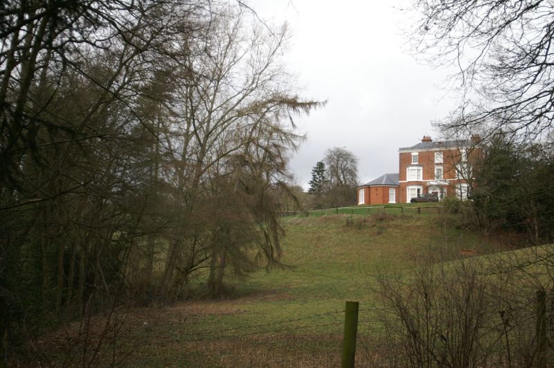
House. Late C18 with early and late C19 additions. Red brick; slate
roof; brick stacks. Aligned east-west facing south with extensions to
the rear and to the south-west angle. 3 storey with corbelled eaves cornice.
1:1:1 bays; central break; 2-storey canted bay windows to left and right,
each of 3 lights divided by pilasters; plate glass sashes to ground floor,
otherwise glazing bar sashes, central windows have raised architraves.
Bracketed sill to first floor and cornice hood to second floor; second
floor windows to left and right have segmental lintels and fluted keys;
first floor sill band. Central C19 semi-octagonal porch; flanking plate
glass sashes with gauged brick heads and pedimented and pilastered door-
case with 6-panelled 2-leaf door and fanlight with traceried glazing bars;
corbelled cornice; surmounted by a statue of an eagle. Late C19 single-
storey polygonal extension with hipped roof to the left. East front: 3
storeys; 4 windows, glazing bar sashes with segmental lintels and first
floor still band.
Listing NGR: SO8216184537
External links are from the relevant listing authority and, where applicable, Wikidata. Wikidata IDs may be related buildings as well as this specific building. If you want to add or update a link, you will need to do so by editing the Wikidata entry.


Other nearby listed buildings