Approximate Location Map
Large Map »
Latitude: 54.997 / 54°59'49"N
Longitude: -1.4353 / 1°26'6"W
OS Eastings: 436226
OS Northings: 567082
OS Grid: NZ362670
Mapcode National: GBR LBFN.2H
Mapcode Global: WHD4R.XNQL
Plus Code: 9C6WXHW7+RV
Entry Name: 16, Barrington Street
Listing Date: 1 February 1983
Grade: II
Source: Historic England
Source ID: 1231574
English Heritage Legacy ID: 406726
ID on this website: 101231574
Location: South Shields, South Tyneside, Tyne and Wear, NE33
County: South Tyneside
Electoral Ward/Division: Beacon and Bents
Parish: Non Civil Parish
Built-Up Area: South Shields
Traditional County: Durham
Lieutenancy Area (Ceremonial County): Tyne and Wear
Church of England Parish: South Shields St Hilda with St Thomas
Church of England Diocese: Durham
Tagged with: Building
This list entry was subject to a Minor Amendment on 2 November 2022 to reformat the text to current standards.
NZ 3667 SW
4/2
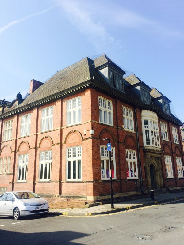
BARRINGTON STREET (south side)
No 16
II
1882. J H Morton architect. 1904. Addition in Nelson Street J H Morton architect. Built for the South Shields Poor Law Union soon after the opening of their new workhouse also designed by Morton.
Red brick and hipped slate roof, modillion eaves cornice. Two storeys and attics. Five bays to Barrington Street, three bays to Nelson Street. A building in the revived English domestic style. The bays marked by brick pilasters, the windows with transoms and mullions. The entrance is semi-circular hooded, framed by an Ionic doorcase with straight entablature. The spandrels are decorated and have the date 1882. Above this an oriel. There are three large dormers, with hipped slate roofs and each with four casements. Continuous cill band to ground and first floor windows. The extension to Nelson Street is of three storeys and five bays. It reflects the style of the earlier building. Elevation has an overall stepped gable, set in the apex a cartouche inscribed Union Office and dated 1904.
Listing NGR: NZ3622667082
External links are from the relevant listing authority and, where applicable, Wikidata. Wikidata IDs may be related buildings as well as this specific building. If you want to add or update a link, you will need to do so by editing the Wikidata entry.


Other nearby listed buildings
