Approximate Location Map
Large Map »
Latitude: 53.3619 / 53°21'42"N
Longitude: -2.0366 / 2°2'11"W
OS Eastings: 397664
OS Northings: 385001
OS Grid: SJ976850
Mapcode National: GBR GY6K.WL
Mapcode Global: WHBB4.PRDL
Plus Code: 9C5V9X67+Q9
Entry Name: Hagg Bank Farmhouse
Listing Date: 17 November 1983
Grade: II
Source: Historic England
Source ID: 1231583
English Heritage Legacy ID: 406488
ID on this website: 101231583
Location: Disley, Cheshire East, Cheshire, SK12
County: Cheshire East
Civil Parish: Disley
Built-Up Area: New Mills
Traditional County: Cheshire
Lieutenancy Area (Ceremonial County): Cheshire
Church of England Parish: Disley St Mary
Church of England Diocese: Chester
Tagged with: Farmhouse
SJ 98 NE DISLEY C.P. HAGG BANK LANE
SJ 9784 (West Side)
2/29 and 7/29 Hagg Bank Farmhouse
II
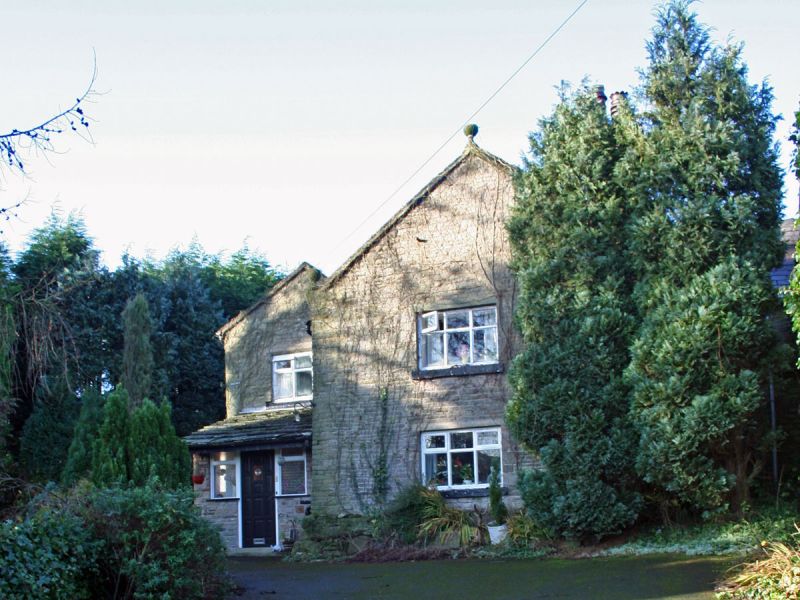
Farmhouse: dated 1695 with C18 and late C19 additions and alterations.
Coursed, squared sandstone rubble with sandstone dressings, Welsh
slate roof and 2 brick chimneys. Core is a 2-room parlour wing of
L-shaped farm, with additions to south and west sides. Single bay
gabled front with kneelers, bead-moulded coping and ball finials has
late C19 wooden casements. A 4-light rubble stone, chamfered mullion
window with a hood mould to the rear and a similar 3-light to the left
suggest the originals. A C18 extension to the left, but set back, has
original, but moved, moulded stone doorcase with raised centre
containing the date. This is hidden behind late C19 porch.
Interior: Original plan survives with parlour to front, larder to
rear, and 2 bedrooms above. Dogleg stairwell reveals some timber
framing and has original door with 6 flat panels and fluted rails. An
ovolo-moulded beam survives in parlour as do traces of a corner
fireplace.
Listing NGR: SJ9766485001
External links are from the relevant listing authority and, where applicable, Wikidata. Wikidata IDs may be related buildings as well as this specific building. If you want to add or update a link, you will need to do so by editing the Wikidata entry.


Other nearby listed buildings
