Latitude: 51.355 / 51°21'18"N
Longitude: -0.2522 / 0°15'8"W
OS Eastings: 521796
OS Northings: 163224
OS Grid: TQ217632
Mapcode National: GBR 9X.F2C
Mapcode Global: VHGRP.L60K
Plus Code: 9C3X9P4X+24
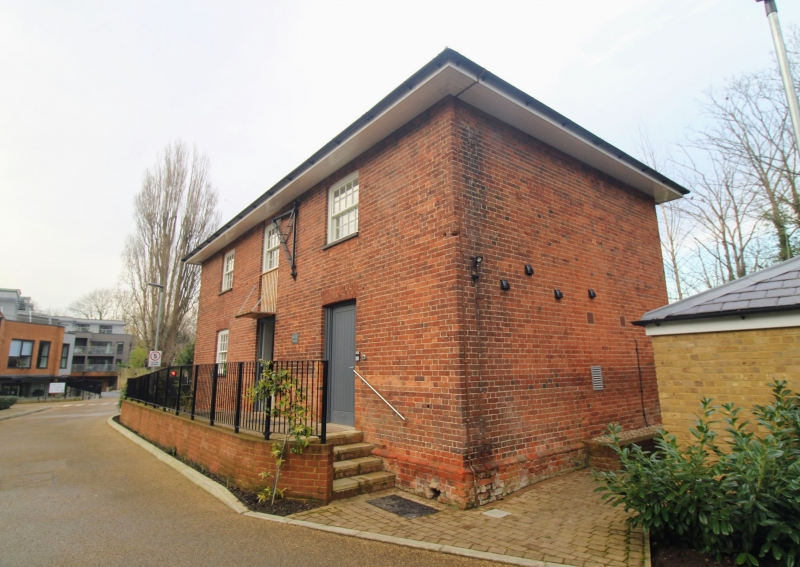
Entry Name: Former Outhouse in grounds of Lower Mill
Listing Date: 22 March 1974
Grade: II
Source: Historic England
Source ID: 1231885
English Heritage Legacy ID: 407154
ID on this website: 101231885
Location: Ewell, Epsom and Ewell, Surrey, KT17
County: Surrey
District: Epsom and Ewell
Electoral Ward/Division: Ewell
Parish: Non Civil Parish
Built-Up Area: Ewell
Traditional County: Surrey
Lieutenancy Area (Ceremonial County): Surrey
Church of England Parish: Ewell St Mary the Virgin
Church of England Diocese: Guildford
Tagged with: Outhouse
This list entry was subject to a Minor Amendment on 7 May 2025 to update the Name and Address and reformat the text to current standards
TQ 2163
16/332
EWELL
KINGSTON ROAD (West Side)
Lower Mill
The Granary
(Formerly listed as Outhouse in grounds of Lower Mill)
II
Early C19. Red brick. Hipped slate roof with overhanging eaves. Two storeys. Two ranges of fixed windows with glazing bars. Loft door set in continuous panel with, and above, entrance door.
Listing NGR: TQ2179663224
External links are from the relevant listing authority and, where applicable, Wikidata. Wikidata IDs may be related buildings as well as this specific building. If you want to add or update a link, you will need to do so by editing the Wikidata entry.


Other nearby listed buildings