Approximate Location Map
Large Map »
Latitude: 54.9977 / 54°59'51"N
Longitude: -1.4394 / 1°26'21"W
OS Eastings: 435960
OS Northings: 567155
OS Grid: NZ359671
Mapcode National: GBR LBDN.58
Mapcode Global: WHD4R.VNR2
Plus Code: 9C6WXHX6+36
Entry Name: Alum House Ham (Tyne Dock Engineering Company Limited)
Listing Date: 15 March 1983
Grade: II
Source: Historic England
Source ID: 1232320
English Heritage Legacy ID: 407677
ID on this website: 101232320
Location: South Shields, South Tyneside, Tyne and Wear, NE33
County: South Tyneside
Electoral Ward/Division: Beacon and Bents
Parish: Non Civil Parish
Built-Up Area: South Shields
Traditional County: Durham
Lieutenancy Area (Ceremonial County): Tyne and Wear
Church of England Parish: South Shields St Hilda with St Thomas
Church of England Diocese: Durham
Tagged with: Architectural structure
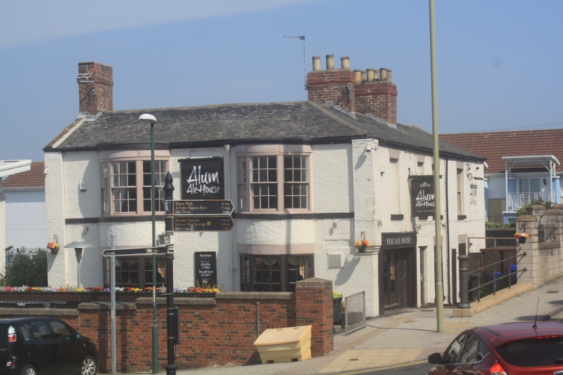
1.
5102 RIVER DRIVE
(Ferry Street)
Tyne Dock Engineering Co Ltd
NZ 36 NE 12/63
II
2.
Early C19.
Brick, now painted, slate roof. Three storeys and 2 bays to west elevation,
2 storeys and 4 bays to south elevation. Stone heads to windows.
The principal west elevation has 2 elegant segmental bow windows through the
3 storeys. The bows have 3 lights mostly with the original curved sashes. The
ground windows are blocked. Continuous stone cill band at first and second floors.
The corners of this elevation are marked by broad pilasters. An elegant elevation
and the only one of its type to survive within the old town.
On the long south elevation the 2 western first floor bays are blind the other
2 sashed. The ground floor has 2 sashed windows below those on the first floor and
an unadorned door to the west. The western end of this elevation had a C19 public
house front when it was called "The Alum House".
Listing NGR: NZ3596067155
External links are from the relevant listing authority and, where applicable, Wikidata. Wikidata IDs may be related buildings as well as this specific building. If you want to add or update a link, you will need to do so by editing the Wikidata entry.


Other nearby listed buildings
