Latitude: 50.9883 / 50°59'18"N
Longitude: -1.4962 / 1°29'46"W
OS Eastings: 435458
OS Northings: 121113
OS Grid: SU354211
Mapcode National: GBR 758.SPP
Mapcode Global: FRA 76RH.NXR
Plus Code: 9C2WXGQ3+8G
Entry Name: 3-7, Palmerston Street
Listing Date: 28 August 1951
Grade: II
Source: Historic England
Source ID: 1232430
English Heritage Legacy ID: 407818
ID on this website: 101232430
Location: Romsey, Test Valley, Hampshire, SO51
County: Hampshire
District: Test Valley
Civil Parish: Romsey
Built-Up Area: Romsey
Traditional County: Hampshire
Lieutenancy Area (Ceremonial County): Hampshire
Church of England Parish: Romsey St Mary and St Ethelflaeda
Church of England Diocese: Winchester
Tagged with: Building
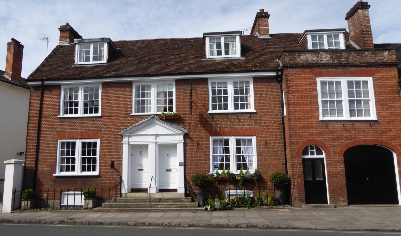
PALMERSTON STREET 1. (West Side) 1559 Nos 3 to 7 (odd) SU 3521 4/69 28.8.51.
II GV
2. C18. 2-storeys and attic with basement. Red brick. Old tile roof with 3 dormer casements. No 3 projects forward from Nos 5 and 7. 2-storeys and attic. Cornice with small modillions and capped parapet. Former stable block but under same roof span as Nos 5 and 7. Segmental-arched stable door to right hand. To left hand, 4-panel door (2 lower panels fielded, 2 upper panels glazed); semi-circular fanlight with rectangular glazing over. Double window above this. Nos 5 and 7. 2 flat-roofed dormers. Moulded wood eaves cornice. On 1st floor, 3 double sash windows (though central pair false). 2 similar windows (without glazing bars) on ground floor. Central pair of 6-panel doors in panelled reveals, flanked and divided by Doric pilasters with continuous entablature broken forward over pilasters, and grouped under large moulded and dentilled parapet. Approached by 4 steps. 2 basement windows. All the listed buildings in Palmerston Street with Nos 70 to 84 (even) and 47 to 55 (odd) The Hundred form a group.
Listing NGR: SU3545721108
External links are from the relevant listing authority and, where applicable, Wikidata. Wikidata IDs may be related buildings as well as this specific building. If you want to add or update a link, you will need to do so by editing the Wikidata entry.


Other nearby listed buildings