Approximate Location Map
Large Map »
Latitude: 55.6088 / 55°36'31"N
Longitude: -1.7151 / 1°42'54"W
OS Eastings: 418044
OS Northings: 635059
OS Grid: NU180350
Mapcode National: GBR J3GL.G7
Mapcode Global: WHC0L.M9H1
Plus Code: 9C7WJ75M+GX
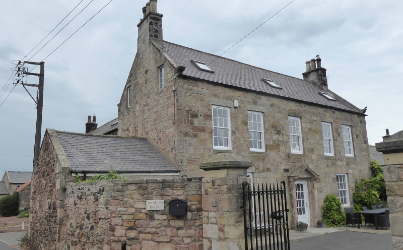
Entry Name: Wynding House
Listing Date: 3 December 1986
Grade: II
Source: Historic England
Source ID: 1233046
English Heritage Legacy ID: 408477
ID on this website: 101233046
Location: Bamburgh, Northumberland, NE69
County: Northumberland
Civil Parish: Bamburgh
Built-Up Area: Bamburgh
Traditional County: Northumberland
Lieutenancy Area (Ceremonial County): Northumberland
Church of England Parish: Bamburgh St Aidan
Church of England Diocese: Newcastle
Tagged with: House
BAMBURGH THE WYNDING
NU 13 NE
(East side)
4/63 Wynding House
3.12.86
GV II
House. Early-mid C18. Ashlar with Welsh slate roof. 2 storeys, 5 windows.
On ground floor C20 door in open-pedimented stone surround. Flanking, renewed
12-pane sashes. On 1st floor 5 renewed 12-pane sashes. Steeply-pitched gabled
roof with kneelers and banded end stacks.
Listing NGR: NU1804735060
External links are from the relevant listing authority and, where applicable, Wikidata. Wikidata IDs may be related buildings as well as this specific building. If you want to add or update a link, you will need to do so by editing the Wikidata entry.


Other nearby listed buildings
