Approximate Location Map
Large Map »
Latitude: 50.9894 / 50°59'21"N
Longitude: 0.5474 / 0°32'50"E
OS Eastings: 578882
OS Northings: 124198
OS Grid: TQ788241
Mapcode National: GBR PVK.TFL
Mapcode Global: FRA D61H.F44
Plus Code: 9F22XGQW+QX
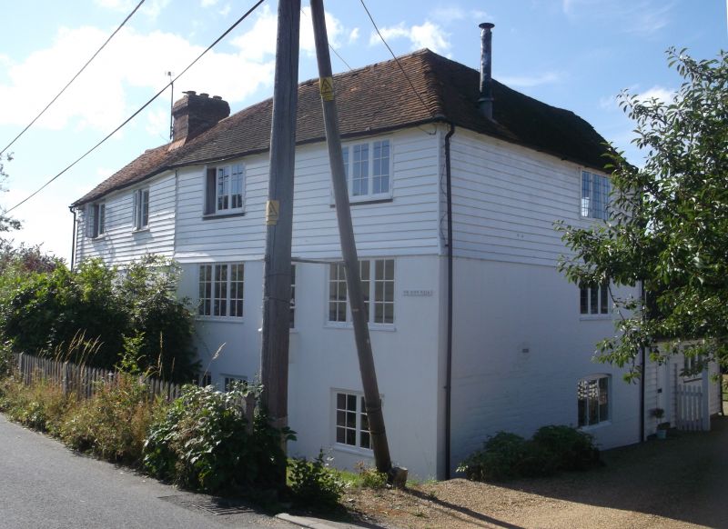
Entry Name: The Rope Walk
Listing Date: 13 May 1987
Grade: II
Source: Historic England
Source ID: 1233944
English Heritage Legacy ID: 409544
ID on this website: 101233944
Location: Snagshall, Rother, East Sussex, TN32
County: East Sussex
District: Rother
Civil Parish: Ewhurst
Traditional County: Sussex
Lieutenancy Area (Ceremonial County): East Sussex
Church of England Parish: Ewhurst St James the Great
Church of England Diocese: Chichester
Tagged with: Architectural structure
TQ 72 SE EWHURST SNAGSHALL
13/42 The Rope Walk
GV II
Long and tall building with a convex curve in the front, probably used for making
rope originally. Early C19. Three storeys. Five windows. Ground floor
stuccoed, above weather-boarded. Tiled roof. Casement windows.
Listing NGR: TQ7888224198
External links are from the relevant listing authority and, where applicable, Wikidata. Wikidata IDs may be related buildings as well as this specific building. If you want to add or update a link, you will need to do so by editing the Wikidata entry.


Other nearby listed buildings
