Approximate Location Map
Large Map »
Latitude: 51.8816 / 51°52'53"N
Longitude: 0.5778 / 0°34'40"E
OS Eastings: 577520
OS Northings: 223475
OS Grid: TL775234
Mapcode National: GBR PHR.WDV
Mapcode Global: VHJJB.YYTZ
Plus Code: 9F32VHJH+J4
Entry Name: Barn 18 Metres South West of Mark's Farmhouse
Listing Date: 23 May 1988
Grade: II
Source: Historic England
Source ID: 1234796
English Heritage Legacy ID: 113829
ID on this website: 101234796
Location: Braintree, Essex, CM7
County: Essex
District: Braintree
Electoral Ward/Division: Bocking Blackwater
Parish: Non Civil Parish
Built-Up Area: Braintree
Traditional County: Essex
Lieutenancy Area (Ceremonial County): Essex
Church of England Parish: Bocking St Peter
Church of England Diocese: Chelmsford
Tagged with: Barn
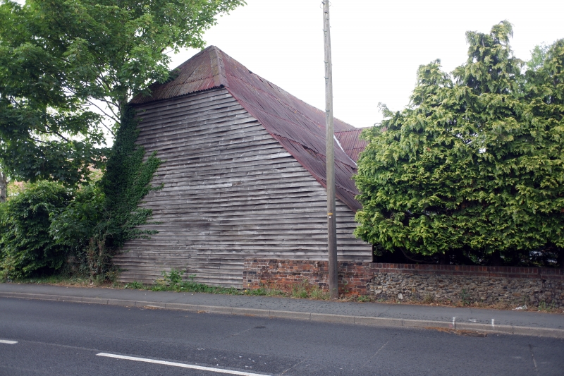
TL 72 SE COGGESHALL ROAD
BRAINTREE
5/231 Barn 18m SW of Mark's Farmhouse
GV II
Barn. Mid to late C17. Timber framed and weatherboarded, with corrugated iron roof. 5 bays with half hipped midstrey lean-to extension on east side. Frame is virtually complete, with arch braced tie beams, main posts without jowls and joggled side girths. Gambrel roof with side purlins, arch braced main collars, and upper purlins with simple collars. Halved and Bladed top plate scarfs. End gables partially rebuilt early C19.
Listing NGR: TL7752023475
External links are from the relevant listing authority and, where applicable, Wikidata. Wikidata IDs may be related buildings as well as this specific building. If you want to add or update a link, you will need to do so by editing the Wikidata entry.


Other nearby listed buildings
