Latitude: 51.1661 / 51°9'57"N
Longitude: 0.962 / 0°57'43"E
OS Eastings: 607184
OS Northings: 144929
OS Grid: TR071449
Mapcode National: GBR SXY.XQ6
Mapcode Global: VHKKH.MYGG
Plus Code: 9F325X86+CR
Entry Name: Barns About 20 Metres North of Sankey Farmhouse
Listing Date: 16 February 1989
Grade: II
Source: Historic England
Source ID: 1235052
English Heritage Legacy ID: 410075
ID on this website: 101235052
Location: Troy Town, Ashford, Kent, TN25
County: Kent
District: Ashford
Civil Parish: Wye with Hinxhill
Built-Up Area: Brook
Traditional County: Kent
Lieutenancy Area (Ceremonial County): Kent
Tagged with: Barn
TR 04 SE WYE BROOK ROAD
(west side)
4/215 Barns about
20 metres
north of
Sankey
Farmhouse
GV II
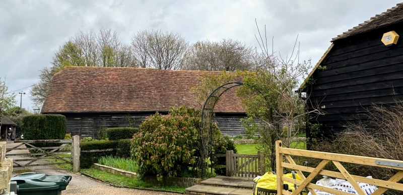
Barns. C18 or earlier. Timber framed and weather boarded with plain
tiled roofs. Two builds, both on red brick bases, that to right hipped,
the roof stepped up and out to left hand block with half-hip. Boarded
door to centre left. Rear elevations without projections or features.
Included for group value.
Listing NGR: TR0716644907
External links are from the relevant listing authority and, where applicable, Wikidata. Wikidata IDs may be related buildings as well as this specific building. If you want to add or update a link, you will need to do so by editing the Wikidata entry.


Other nearby listed buildings