Approximate Location Map
Large Map »
Latitude: 51.3435 / 51°20'36"N
Longitude: 0.3322 / 0°19'55"E
OS Eastings: 562526
OS Northings: 163069
OS Grid: TQ625630
Mapcode National: GBR Z2.4DY
Mapcode Global: VHHPG.PHYG
Plus Code: 9F3288VJ+9V
Entry Name: Holywell Farmhouse
Listing Date: 22 October 1982
Grade: II
Source: Historic England
Source ID: 1235109
English Heritage Legacy ID: 411271
ID on this website: 101235109
Location: Hodsoll Street, Sevenoaks, Kent, TN15
County: Kent
District: Sevenoaks
Civil Parish: Ash-cum-Ridley
Traditional County: Kent
Lieutenancy Area (Ceremonial County): Kent
Church of England Parish: Ash St Peter and St Paul
Church of England Diocese: Rochester
Tagged with: Farmhouse
ASH-CUM-RIDLEY HODSOLL STREET
1.
5280
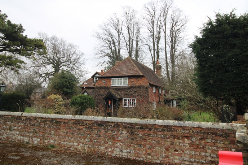
Holywell Farmhouse
TQ 66 SW 7/12
II GV
2.
C17 or earlier timber-framed building of 2 storeys refaced with red brick on the
ground floor and tile hung above and one window bay added at the west end. Tiled
roof. Massive chimney breast with offsets on the east wall. Four casement
windows, including the addition.
Listing NGR: TQ6252663069
External links are from the relevant listing authority and, where applicable, Wikidata. Wikidata IDs may be related buildings as well as this specific building. If you want to add or update a link, you will need to do so by editing the Wikidata entry.


Other nearby listed buildings
