Approximate Location Map
Large Map »
Latitude: 52.9037 / 52°54'13"N
Longitude: -0.9248 / 0°55'29"W
OS Eastings: 472418
OS Northings: 334573
OS Grid: SK724345
Mapcode National: GBR BM3.T7F
Mapcode Global: WHFJD.R8TS
Plus Code: 9C4XW33G+F4
Entry Name: The Unicorns Head Public House
Listing Date: 12 February 1952
Grade: II
Source: Historic England
Source ID: 1235976
English Heritage Legacy ID: 426868
ID on this website: 101235976
Location: Langar, Rushcliffe, Nottinghamshire, NG13
County: Nottinghamshire
District: Rushcliffe
Civil Parish: Langar cum Barnstone
Traditional County: Nottinghamshire
Lieutenancy Area (Ceremonial County): Nottinghamshire
Church of England Parish: Langar cum Barnstone
Church of England Diocese: Southwell and Nottingham
Tagged with: Pub
LANGAR CUM BARNSTONE MAIN STREET
SK73SW (east side)
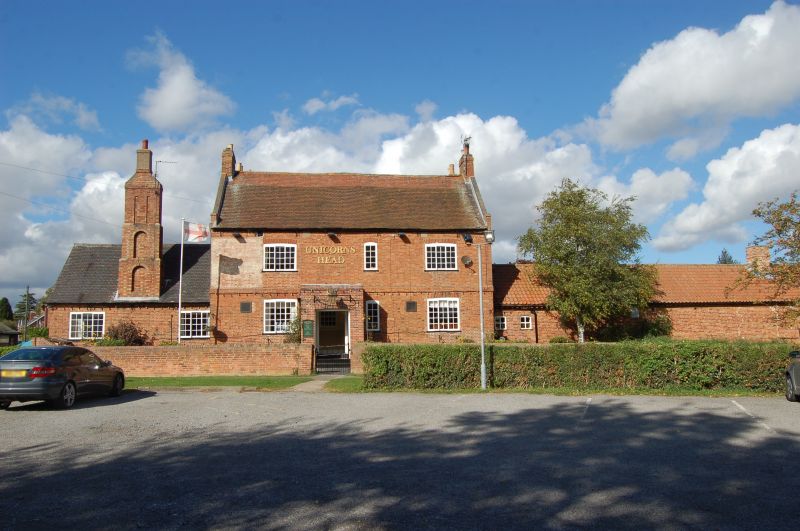
5/124 The Unicorn's Head,
Public House
12.2.52
- II
Public house. Dated 1717. Brick. Twin, plain-tile roofs, steeply
pitched with coped gables on square kneelers and end stacks. Two
storeys. Double depth plan. Near-symmetrical 3-bay facade. C20
square brick porch. To each side is a tripartite C20 casement window
with shallow segmental head. Two similar windows to 1st floor and a
single-light small casement. Three-course brick band between floors.
To the left is a later, lower, single-storey 2-bay brew-house addition
with a tall 3-stage reducing stack rising from the centre of its front
wall. The stack has a blind arch to each stage. The rear of the
main building is also of 3 bays. The ground floor is obscured by a
later porch. Central, tall stair window. One bipartite casement to
each side at lst-floor level. A band runs across the twin left gables
and the rear gable has the date 1717 picked out in coloured brick.
Interior: not inspected.
Listing NGR: SK7241834573
External links are from the relevant listing authority and, where applicable, Wikidata. Wikidata IDs may be related buildings as well as this specific building. If you want to add or update a link, you will need to do so by editing the Wikidata entry.


Other nearby listed buildings
