Latitude: 51.2078 / 51°12'28"N
Longitude: -1.4793 / 1°28'45"W
OS Eastings: 436471
OS Northings: 145528
OS Grid: SU364455
Mapcode National: GBR 72R.BS7
Mapcode Global: VHC2S.9WTZ
Plus Code: 9C3W6G5C+47
Entry Name: Guildhall
Listing Date: 24 February 1950
Grade: II*
Source: Historic England
Source ID: 1236337
English Heritage Legacy ID: 139514
ID on this website: 101236337
Location: Andover, Test Valley, Hampshire, SP10
County: Hampshire
District: Test Valley
Civil Parish: Andover
Built-Up Area: Andover
Traditional County: Hampshire
Lieutenancy Area (Ceremonial County): Hampshire
Church of England Parish: Andover St Mary
Church of England Diocese: Winchester
Tagged with: City hall Seat of local government
SU 3645 NW ANDOVER HIGH STREET
4/56 Guildhall
24.2.50
II*
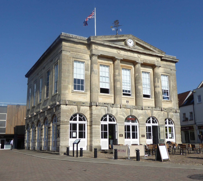
Formerly Town Hall, 1825. A successor to a guildhall of 1725 to 1825, of similar
form. A Greek Doric stone building, almost a cube, with 4 symmetrical elevations, a
typical English Renaissance design, of a tall room above an open arcaded ground floor
(now enclosed). The front (south) is of 1.3.1 bays. Blocking course above a Doric
cornice, with omutile boxes, continuous frieze (without triglyphs) and continuous
guttee below a tenia, plain architrave (with circular decorations above the columns);
the central pediment encloses a circular opening containing a clock; 4 fluted Doric
columns (3/4 attached) stand on the projected centrepiece, the wings terminating in
parallel-sided pilasters. With a continuous base moulding. First floor band
(continued into keystones), rusticated ground floor of 4 bands above an impost band
then 5 bands above a (granite) plinth. Sashes in reveals to the upper floor,
half-glazed filling of later date to the ground floor openings. The north elevation
has a plainer upper part and fanlights within the arcade but the centre 3 bays of the
ground floor project forward, with a pediment and central entrance. The side
elevations (east and west) are the same, of 5 bays, having a regular pilaster
treatment to the upper floor. Low-pitched hipped slate roof (unseen). Within the
north side entrance leads to a lobby, with staircases on each side leading upwards
through an apse with 2 niches to an upper lobby from which a single flight reaches the
upper hall. [There was once a central clock tower].
Listing NGR: SU3647045523
External links are from the relevant listing authority and, where applicable, Wikidata. Wikidata IDs may be related buildings as well as this specific building. If you want to add or update a link, you will need to do so by editing the Wikidata entry.


Other nearby listed buildings