Approximate Location Map
Large Map »
Latitude: 51.4934 / 51°29'36"N
Longitude: -0.153 / 0°9'10"W
OS Eastings: 528319
OS Northings: 178775
OS Grid: TQ283787
Mapcode National: GBR 9L.TV
Mapcode Global: VHGQZ.9QGK
Plus Code: 9C3XFRVW+8R
Entry Name: 24, SOUTH EATON PLACE SW1 (See details for further address information)
Listing Date: 1 December 1987
Grade: II
Source: Historic England
Source ID: 1236481
English Heritage Legacy ID: 427482
ID on this website: 101236481
Location: Belgravia, Westminster, London, SW1W
County: London
District: City of Westminster
Electoral Ward/Division: Knightsbridge and Belgravia
Parish: Non Civil Parish
Built-Up Area: City of Westminster
Traditional County: Middlesex
Lieutenancy Area (Ceremonial County): Greater London
Church of England Parish: St Michael Chester Square
Church of England Diocese: London
Tagged with: Building
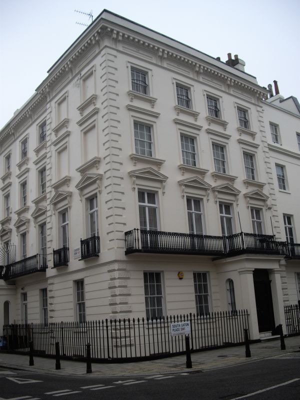
TQ 2878 NW CITY OF WESTMINSTER SOUTH EATON PLACE, SW1
102/22 (west side)
No 24 (including
Nos 24 and 26
Chester Road )
GV II
Corner block of terraced houses. Mid C19. Stucco. Roofs not visible. Facade
to South Eaton Place of 4 bays, 4 storeys and basement. Projecting pilastered
Doric porch to third bay from left. Panelled door. Channelling to ground
floor. First floor cast iron balcony. First floor windows pedimented; second
floor windows corniced; all windows architraved above ground floor. Rusticated
quoins. Return to Chester Row, to which with Nos 24 and 26 it probably presented
orginally abalanced composition, but No 26 apparently simplified. Cast iron area
railings.
Listing NGR: TQ2831978775
External links are from the relevant listing authority and, where applicable, Wikidata. Wikidata IDs may be related buildings as well as this specific building. If you want to add or update a link, you will need to do so by editing the Wikidata entry.


Other nearby listed buildings
