Approximate Location Map
Large Map »
Latitude: 51.3075 / 51°18'27"N
Longitude: 0.3099 / 0°18'35"E
OS Eastings: 561102
OS Northings: 159025
OS Grid: TQ611590
Mapcode National: GBR Y9.JSF
Mapcode Global: VHHPN.BD6H
Plus Code: 9F328855+2X
Entry Name: The Almshouses
Listing Date: 30 May 1984
Grade: II
Source: Historic England
Source ID: 1236528
English Heritage Legacy ID: 427548
ID on this website: 101236528
Location: Wrotham, Tonbridge and Malling, Kent, TN15
County: Kent
District: Tonbridge and Malling
Civil Parish: Wrotham
Built-Up Area: Wrotham
Traditional County: Kent
Lieutenancy Area (Ceremonial County): Kent
Church of England Parish: Wrotham St George
Church of England Diocese: Rochester
Tagged with: Almshouse
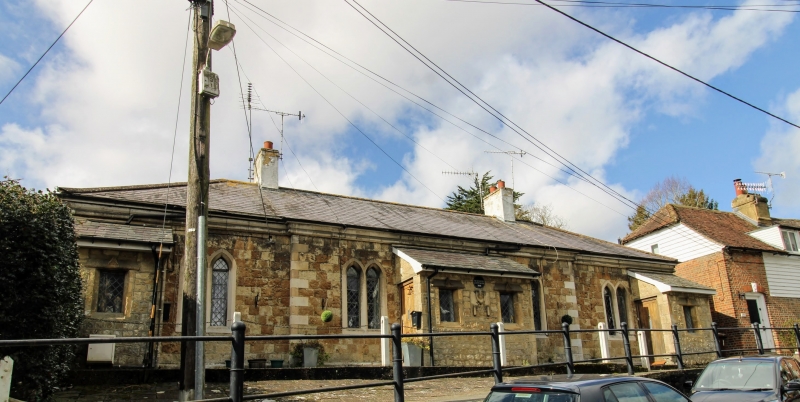
TQ6059-6159 WROTHAM C.P. ST MARY'S LANE
7/25 (west side)
The Almshouses, Nos
1-4, (Incl)
GV
II
Almshouse row. Dated 1806 by John Carter. Coursed galletted rubble stone with
ashlar dressings on ashlar plinth. Moulded cornice to slate hipped roof with
2 ridge stacks. Central pair of houses project slightly with dressed quoins.
1 storey; 4 pairs of lancet casements, divided by 3 lean-to projections, doubled in
centre, with 4 boarded doors facing each other in their sides. These entrance
projections seem to have been thrown forward at a later date, re-using drip-moulds
from window that they covered. Crest on central projection with inscription:
BENEVOLENTIA
HELENAE BETENSO
MDCCCVI
See The Gentleman's Magazine, 1817. (ii), 365; M. Colvin, A Biographical Dictionary
of British Architects, 1600 to 1840, 1978, 200.
Listing NGR: TQ6110159027
External links are from the relevant listing authority and, where applicable, Wikidata. Wikidata IDs may be related buildings as well as this specific building. If you want to add or update a link, you will need to do so by editing the Wikidata entry.


Other nearby listed buildings
