Latitude: 52.9332 / 52°55'59"N
Longitude: -1.1391 / 1°8'20"W
OS Eastings: 457960
OS Northings: 337660
OS Grid: SK579376
Mapcode National: GBR LRX.JN
Mapcode Global: WHDGZ.GJSP
Plus Code: 9C4WWVM6+78
Entry Name: Meadows Suspension Bridge
Listing Date: 31 October 1972
Last Amended: 13 May 1987
Grade: II
Source: Historic England
Source ID: 1237034
English Heritage Legacy ID: 428221
Also known as: Footbridge Over River Trent (That Part In Nottingham Civil Parish)
ID on this website: 101237034
Location: West Bridgford, Rushcliffe, Nottinghamshire, NG2
County: Nottinghamshire
District: Rushcliffe
Electoral Ward/Division: Trent Bridge
Parish: Non Civil Parish
Built-Up Area: West Bridgford
Traditional County: Nottinghamshire
Lieutenancy Area (Ceremonial County): Nottinghamshire
Church of England Parish: West Bridgford
Church of England Diocese: Southwell and Nottingham
Tagged with: Suspension bridge Bridge Bicycle bridge Piping Pipe bridge Footbridge Pipeline bridge
SK 53 NE,
1/18
WEST BRIDGFORD,
WELBECK ROAD,
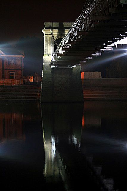
Meadows Suspension Bridge (south-east end)
(Formerly listed as footbridge over River Trent)
31.10.72
II
Suspension footbridge. 1906. Restored 1983. Possibly by M.O.Tarbotton. Plain
and rockfaced ashlar and wrought iron, Battered, buttressed suspension towers
have each a moulded, keystoned round headed arch with iron lamp bracket. Above,
similar arches flanked by paired Doric columns carrying entablature and parapet.
Wooden deck has latticed guard rail. Approach ramps have each 2 round headed
passageways, and moulded plinths carrying iron railings. See also City of
Nottingham list.
Listing NGR: SK5796037660
External links are from the relevant listing authority and, where applicable, Wikidata. Wikidata IDs may be related buildings as well as this specific building. If you want to add or update a link, you will need to do so by editing the Wikidata entry.


Other nearby listed buildings