Approximate Location Map
Large Map »
Latitude: 51.0552 / 51°3'18"N
Longitude: -2.4138 / 2°24'49"W
OS Eastings: 371094
OS Northings: 128513
OS Grid: ST710285
Mapcode National: GBR MZ.FVMK
Mapcode Global: FRA 56TB.CG5
Plus Code: 9C3V3H4P+3F
Entry Name: The Churchyard Gates and Boundary Walls to North and West, Church of St Peter and St Paul
Listing Date: 24 March 1961
Last Amended: 25 January 1985
Grade: II
Source: Historic England
Source ID: 1238554
English Heritage Legacy ID: 416094
ID on this website: 101238554
Location: Wincanton, Somerset, BA9
County: Somerset
District: South Somerset
Civil Parish: Wincanton
Built-Up Area: Wincanton
Traditional County: Somerset
Lieutenancy Area (Ceremonial County): Somerset
Tagged with: Building
ST7128 WINCANTON CP CHURCH STREET (South side)
8/131 The Churchyard gates and boundary
walls to North and West, Church
of St Peter and St Paul
(formerly listed as Gate Piers
and Gates of Churchyard)
24.3.61
GV II
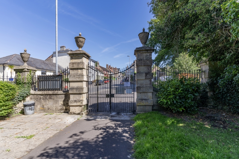
Boundary walls and gates. 1818. Local stone rubble, mostly cut and squared, with ashlar piers; wrought iron gates. North
East gateway nearest the town and grander than the others; gatepiers about 600mm square; plinths, rusticated ashlar,
moulded flat caps, and Adam style urns as finials, with sweeps of railings with barbed spear points to curved toprail
to matching side piers, the central piers being about 3 metres high and the outer 2.5 metres high; gates have barbed
spear finals to curved tops, and Greek key ornament to middle rails. The North West gate similar in detail but smaller
in scale. The South West gate has plain ashlar piers about 400 mm wide and 2 metres high, with moulded pyramidal caps;
the gates have plain points to rails, with quatrefoil in middle rails and applied curves to top rail. Linking walls
vary in height with slope of ground but average 1.5 metres; tops finished with cement flaunching. An essential part of
the street scene around the church, dating from the extension and enclosure of the churchyard in 1818. Only North East
gateway previously listed. (Sweetman G, History of Wincanton, c1904).
Listing NGR: ST7109428513
External links are from the relevant listing authority and, where applicable, Wikidata. Wikidata IDs may be related buildings as well as this specific building. If you want to add or update a link, you will need to do so by editing the Wikidata entry.


Other nearby listed buildings
